Skip to content
Zhanna's SurveyStation
Menu
About
Recoveries
NGS Reports
USGS Reports
Search Recoveries
Map of Recoveries
Browse By Year
Local Databases
USGS Datasheets
Airway Beacons
About Airway Beacons
Eastern U.S.
Western U.S.
Map of Airway Beacons
Historical Airway Maps
Resources
Contact
Zhanna's SurveyStation
Menu
About
Recoveries
NGS Reports
USGS Reports
Search Recoveries
Map of Recoveries
Browse By Year
Local Databases
USGS Datasheets
Airway Beacons
About Airway Beacons
Eastern U.S.
Western U.S.
Map of Airway Beacons
Historical Airway Maps
Resources
Contact
Location:
Honesdale Quad
1353.170
USGS
Bench Mark Disk
Honesdale Quad
Pennsylvania
Wayne County
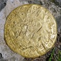
08-63-0006-3
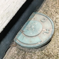
PennDOT
Survey Control Mark
Honesdale Quad
Pennsylvania
Wayne County
I
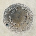
PA Dept. of Highways
Survey Disk
Honesdale Quad
Pennsylvania
Wayne County
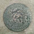
TT 14 T
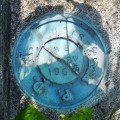
USGS
Transit Traverse Station Disk
Honesdale Quad
Pennsylvania
Wayne County
TT 8 J
USGS
Transit Traverse Station Disk
Honesdale Quad
Pennsylvania
Wayne County
10-63-2034-4
PennDOT
Survey Control Mark
Honesdale Quad
Pennsylvania
Wayne County
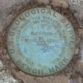
47 DSW
USGS
Elevation Mark
Honesdale Quad
Pennsylvania
Wayne County
PennDOT (Unstamped, #3)
PennDOT
Survey Control Mark
Honesdale Quad
Pennsylvania
Wayne County
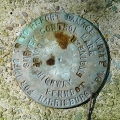
48 DSW
USGS
Elevation Mark
Honesdale Quad
Pennsylvania
Wayne County
TT 9 J
USGS
Transit Traverse Station Disk
Honesdale Quad
Pennsylvania
Wayne County
Older posts
Page
1
Page
2
Next
→