I
Spatial/elevation data
| Coordinates | N 41.56861° W 75.25237° (estimate) |
| Elevation | 973.0 ft. |
| Location | Pennsylvania
Wayne County Honesdale Quad |
Mark description
| Type | Survey Disk |
| Setting | Bridge Abutment |
| Monumented | Unknown by PA Dept. of Highways |
| Description (NGS) | NGS Datasheet |
NGS recovery information
Descriptive text
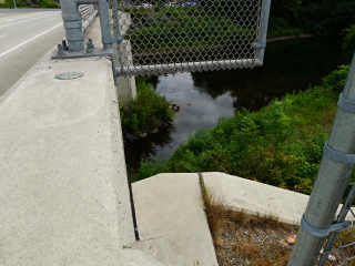
Mark not found. The bridge was renovated in 2009 as part of PennDOT’s Route 6, Honesdale Borough Improvement Project. The mark was either destroyed or covered during bridge construction. A PennDOT survey control mark (08-63-0006-3) was set near the former site of LY1069 at the downstream end of the west side of the bridge.Narrative and photographs
The bridge into which the NGS mark “I” was set was replaced in 2009; see Route 6, Honesdale Borough Improvement Project, Wayne County (link no longer active, August 2024). The Google Street View from 2009 also depicts the bridge work near completion. In the process of bridge replacement, it seems that the mark was destroyed or at least made inaccessible. A new PennDOT survey control mark, 08-63-0006-3, was set near the site of the original mark at the downstream end of the west side of the bridge (although it is on the concrete parapet of the bridge rather than on the abutment).
Interestingly, this span is known as the Philip Hone Bridge, named for the first president of the Delaware & Hudson Canal Company (for whom the town of Honesdale is also named). The original structure was a covered bridge built in 1846-7, which succumbed to a tornado after standing for 20 years. It was replaced twice before the most recent bridge (and the one into which “I” was set in 1951) was built as part of a large project to restore structures destroyed in the 1942 flood. This bridge was widened and the deck was replaced (see above) in 2009.
Source: Bridges span Honesdale’s history, Wayne Independent, October 12, 2009

