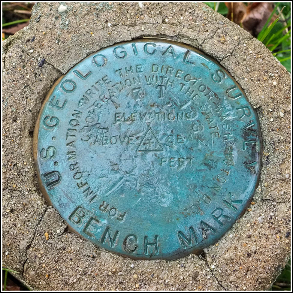
TT 7 T
Spatial/elevation data
| Coordinates | N 41.487697° W 75.555947° |
| Elevation | 922.430 ft. |
| Location | Pennsylvania
Lackawanna County Olyphant Quad |
Mark description
| Type | Bench Mark Disk |
| Setting | Concrete Post |
| Monumented | 1932 by USGS |
| Description (USGS) | Riverside; in S. corner of front yard of Riverside Public School No. 8; in S. corner of schoolyard; 42 ft N. of center of rd [of center of U.S. Highway 6, in Horizontal description].; in concrete post; standard tablet stamped “TT 7 T 1932” |
Narrative and photographs
Rich and I were browsing the topo maps yesterday, looking at some areas of local historical interest (specifically the area near Winton and Archbald labeled Riverside on the map), when we spotted BM 922. We are both certain that we looked for this benchmark in the past and found nothing, although unfortunately we can’t recall the details at this point. But yesterday, we took another look at the area on Google Street View. We were shocked to realize that we could actually see the concrete monument (and even the disk on top) from the Street View! It was right out in the open, atop a grassy slope between a small park and a house. There is no way we could have missed it in the past, assuming that we were in the correct spot all those years ago, and assuming it was exposed like it is now. Our only hypotheses are that we may indeed have been in the wrong spot, or the mark may have been obscured by some brush or landscaping that has since been cleared out. In any case, it was a very exciting prospect, and we planned to scout out the area and, hopefully, recover the mark today.
This morning was warm, sunny, and gorgeous for late October. Although we expected clouds to roll in for the afternoon, the forecast was for dry conditions to remain throughout the day, so we planned our trip for the early afternoon. As our luck would have it, a pretty heavy shower crossed the valley right at that time. We parked at the adjacent lot and walked to the benchmark. The rain wasn’t too heavy, and we had no trouble verifying the mark’s designation and taking a few photos. It’s just a shame that conditions weren’t conducive to poking around further or taking measurements to add to our recovery note.
The disk was recovered in good condition, with faint but legible stamping. The concrete monument has some minor cracks but appears intact and stable. It is approximately 54 feet north of power pole with the numbers 60080/N48869/123. The monument is set on a grassy slope Borough of Archbald’s James Radzelovage Park, which is on the site of the former Riverside Public School No. 8.


