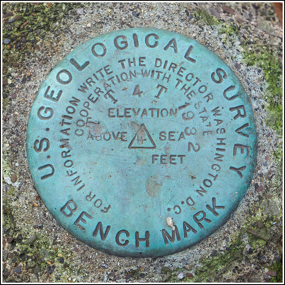
TT 4 T
TT 4 T
Spatial/elevation data
| Coordinates | N 41.405873° W 75.565436° |
| Elevation | 1287.105 ft. |
| Location | Pennsylvania
Lackawanna County Olyphant Quad |
Mark description
| Type | Bench Mark Disk |
| Setting | Concrete Post |
| Monumented | 1932 by USGS |
| Description (USGS) | Elmhurst, 2.25 mi NW. of; 4.6 mi SE. of Dunmore; on U. S. Highway 611; at big horseshoe bend in hwy.; 140 ft S. of front door of service station; 225 ft NW. of concrete bridge over small stream; between hwy. and Erie RR.; 51 ft N. of center of track; in concrete post; standard tablet stamped “TT 4 T 1932” Reference mark; on concrete bridge; Pennsylvania Department of Highways standard disk |
Narrative and photographs
We’ve had our eye on TT 4 T for a few weeks, ever since we started going back through the USGS datasheets for local benchmarks that we somehow missed in the past.
Based on my research, our prospects were favorable. I couldn’t see any reason that this mark would be gone, since it is in an undeveloped area and likely far enough away from the highway to avoid any disturbance from road construction. There is even a convenient parking pull-off very close to the coordinates. The only catch is that this stretch of Route 435 is scheduled to be closed for at least a year due to the replacement of the nearby I-380 twin bridges. And the closure is set to begin two days from now! So although it was a cold morning, we figured we might as well give it a try today.
We drove down from Mt. Cobb, heading west on Route 435 North and then turning around via a section of the old Drinker Turnpike that connects the north- and southbound lanes of Route 435. We parked at the pull-off and noted that we were within 70 feet of the coordinates for the benchmark, which we had estimated from the topo map.
After a short walk into the woods, we reached the coordinates and began wandering around … and spotted nothing other than a very thick layer of fallen leaves. I was beginning to think that the situation was hopeless for the time being, with so many fallen leaves covering the ground. It wouldn’t be the first time we needed to return to a location with a metal detector.
But a moment later, I happened to turn my head to the right, and there was the turquoise-colored disk sitting on top of a concrete post!
“I see it! I see it!” I exclaimed, probably a bit too excitedly, but it was an exciting moment. We both thought the disk looked a bit larger than the usual ones, for some reason. And it is in very good condition. Just a few yards away is the route of the old Erie Railroad, now abandoned and apparently used as a quad trail. A bit farther down the hill, Roaring Brook is visible.
After finishing our photos and documentation of the benchmark, we moved on to look for the nearby reference mark.
Typically, PDH disks are easy to find, and we seem to spot plenty of them on old concrete bridges when we’re not even looking for them. But we had no luck this time. There are two bridge or culvert-like structures at the given distance and direction from the mark. One is concrete and was clear of vegetation, but there was no disk set into it. Just a few yards away was another structure with some old, heavily eroded concrete on the top, and a stone wingwall dated 1939 (seven years after this benchmark was set). Perhaps the reference mark was set in the original bridge in this location, which may be gone now.
We also checked the corresponding portal on the northern side of the road, but that was far too overgrown to have any hope of finding anything on it. Given the distances in the description, it is much more likely that the southern portal was the correct one.
Something else of interest is that the walls of the old service station mentioned in the benchmark description are still here! The remnants of the building are on the north side of the highway, and can even be seen on Google Street View. I haven’t yet been able to find out anything more about the service station, but the name CHICCO can be seen in the concrete.


