Skip to content
Zhanna's SurveyStation
Menu
About
Recoveries
NGS Reports
USGS Reports
Search Recoveries
Map of Recoveries
Browse By Year
Local Databases
USGS Datasheets
Airway Beacons
About Airway Beacons
Eastern U.S.
Western U.S.
Map of Airway Beacons
Historical Airway Maps
Resources
Contact
Zhanna's SurveyStation
Menu
About
Recoveries
NGS Reports
USGS Reports
Search Recoveries
Map of Recoveries
Browse By Year
Local Databases
USGS Datasheets
Airway Beacons
About Airway Beacons
Eastern U.S.
Western U.S.
Map of Airway Beacons
Historical Airway Maps
Resources
Contact
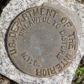
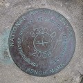
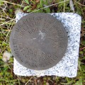
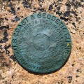
Location:
Hancock County
OTTER
NGS
Landmark/Intersection Station
Hancock County
Seal Harbor Quad
Maine
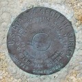
841 3320 TIDAL D
National Ocean Service
Tidal Bench Mark Disk
Hancock County
Bar Harbor Quad
Maine
S 24
National Park Service
Boundary Monument
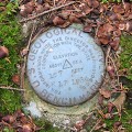
Hancock County
Southwest Harbor Quad
Maine
BEEN 1944
NGS
Topographic Station Disk
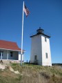
Hancock County
Swans Island Quad
Maine
BURNT COAT HARBOR LIGHTHOUSE
Unknown
Landmark/Intersection Station
Hancock County
Swans Island Quad
Maine
K 17
USGS
Bench Mark Disk
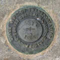
Hancock County
Bartlett Island Quad
Maine
5377
MaineDOT
Survey Mark
Hancock County
Southwest Harbor Quad
Maine
Q 1
National Park Service
Boundary Monument
Hancock County
Bartlett Island Quad
Maine
NPS (Unstamped, Acadia #6)
National Park Service
Boundary Monument
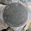
Hancock County
Bass Harbor Quad
Maine
DUKY
NGS
Topographic Station Disk
Hancock County
Bartlett Island Quad
Maine
Older posts
Newer posts
←
Previous
Page
1
…
Page
9
Page
10
Page
11
…
Page
20
Next
→