BEEN 1944 (PE1865)
BEEN 1944
Spatial/elevation data
| Coordinates | N 44.190767° W 68.425116° |
| Elevation | 20 ft. |
| Location | Maine
Hancock County Swans Island Quad |
Mark description
| Type | Topographic Station Disk |
| Setting | Rock Outcrop |
| Monumented | 1944 by NGS |
| Description (NGS) | NGS Datasheet |
NGS recovery information
Descriptive text
Recovered in good condition.Narrative and photographs
Today’s main activity was to explore Swans Island by bicycle. It was the perfect place to ride, and we even enjoyed warm, sunny weather! The roads were narrow and took us past quaint cottages, a post office, and a few small town food stands; I can’t call them restaurants. Traffic was minimal, and drivers were courteous (in fact, almost everyone who passed us waved, and I don’t mean the middle-finger wave so common at home). After cycling our way to the lighthouse and the Carrying Place Sand Beach, we worked our way back north in the direction of the ferry terminal. If time allowed, Rich promised me, we’d see how close we could get to BEEN 1944.
We rode past the “grammer” school, as it is spelled on the Swans Island map, on Rose Hill Road. Just north of the school, the road narrows and the surface turns to gravel and sand. The road ends at a “cottage”—a large farmhouse-style abode with a million dollar view of Mackerel Cove. From here, the straight-line distance to BEEN on North Point was about a quarter mile, but we wouldn’t be able to travel in a straight line.
Of course, without permission we might not be able to travel at all. I climbed onto one of the bare wood porches and knocked several times, but there were no signs that anyone was home. Finally, we decided to see how easily we might walk to the mark along the shore rather than through the woods.
The shoreline here abruptly shifts from woodland to bare rock, massive boulders and cubes of granite that become progressively smaller as the shore stretches out to the sea. I figured that walking along the rocks would be easy and quick enough, and I was game to try it. Rich decided to hang back and wait, which I thought was best for him until he feels more sure of his footing. Wet granite, especially when covered with seaweed, is really slippery!
The rock scramble was fun. I love hoisting myself up and down over boulders and hopping across level areas of cobbles. After a few steps I took off my shoes because the scraping sound of bike cleats on rock was unnerving. In bare feet, the walking was much easier, and I liked the feeling of the warm rocks underfoot. This is certainly the first benchmark I’ve found barefoot!
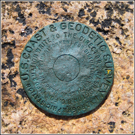
Within a few minutes I closed in on the coordinates and found the disk easily. The stamping is nearly worn off, probably from being in such an exposed location right at the ocean’s edge. But BEEN it was, and I was thrilled to have found another topographic station! They always seem to be in absolutely beautiful, colorful locations perfect for a picnic or just a few hours of relaxing. I wish Rich had been able to make the walk with me, because he would have loved this spot too. I took my photos, as much to share the spot with him as for my benchmark recovery, and then picked my way back across the rocks to where he waited for me on the beach near the cottage, eating snacks. He was thrilled about the find. Next one, we’ll do together!


