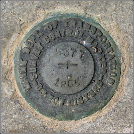
5377
5377
Recovered in Good Condition on June 27, 2009
Spatial/elevation data
| Coordinates | N 44.28995° W 68.265283° |
| Elevation | 11.3911 ft. |
| Location | Maine
Hancock County Southwest Harbor Quad |
Mark description
| Type | Survey Mark |
| Setting | Bridge Wingwall |
| Monumented | 1985 by MaineDOT |
| Description (MaineDOT) | STATION NAME: 5377 NO SURVEY INFORMATION, DISK IS STAMPED WITH THE Maine DOT Bridge Number. Located on State Rte 3, in an area of Mount Desert known locally as Seal Harbor, at the bridge over Little Harbor Brook. The station is a standard disk stamped — 5377 1985 —, cemented in a drill hole in the Northerly curb of bridge, about 200 mm (8 in) above the paved road surface, behind the stone bridge rail, near the Northeast end post and wingwall. |
Narrative and photographs
Today we were on a relaxed tour of some of our favorite hiking and exploring spots. Between watching some rock climbers at Otter Cliffs and visiting the Asticou Azalea Gardens, we stopped at the bridge over Little Harbor Brook to look for a MaineDOT mark I had recently read about on their website. We found the disk just as described on the northeast wingwall of the bridge. We also spotted a very interesting triangular monument nearby, just west of the bridge. I have no idea what this monument might signify—maybe a boundary? It does have some numbers carved or formed into it, but they don’t indicate to me what the monument might be.


