Skip to content
Zhanna's SurveyStation
Menu
About
Recoveries
NGS Reports
USGS Reports
Search Recoveries
Map of Recoveries
Browse By Year
Local Databases
USGS Datasheets
Airway Beacons
About Airway Beacons
Eastern U.S.
Western U.S.
Map of Airway Beacons
Historical Airway Maps
Resources
Contact
Zhanna's SurveyStation
Menu
About
Recoveries
NGS Reports
USGS Reports
Search Recoveries
Map of Recoveries
Browse By Year
Local Databases
USGS Datasheets
Airway Beacons
About Airway Beacons
Eastern U.S.
Western U.S.
Map of Airway Beacons
Historical Airway Maps
Resources
Contact
Location:
Bass Harbor Quad
BASS
Army Corps of Engineers
Survey Mark
Bass Harbor Quad
Maine
Hancock County
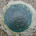
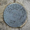
TIDAL 4 STA 13
NGS
Chiseled Cross
Bass Harbor Quad
Maine
Hancock County
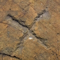
TIDAL 6 STA 13
NGS
Tidal Bench Mark Disk
Bass Harbor Quad
Maine
Hancock County
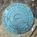
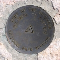
WONDERLAND
National Park Service
Triangulation Station Disk
Bass Harbor Quad
Maine
Hancock County
NPS (Unstamped, Acadia #6)
National Park Service
Boundary Monument
Bass Harbor Quad
Maine
Hancock County
LOP
NGS
Topographic Station Disk
Bass Harbor Quad
Maine
Hancock County
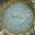
BASS HARBOR RESET RM 2
NGS
Reference Mark Disk
Bass Harbor Quad
Maine
Hancock County
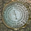
BASS HARBOR RESET RM 1
NGS
Reference Mark Disk
Bass Harbor Quad
Maine
Hancock County
BASS HARBOR RESET
NGS
Copper Bolt
Bass Harbor Quad
Maine
Hancock County
BASS HARBOR HEAD LIGHTHOUSE
Unknown
Landmark/Intersection Station
Bass Harbor Quad
Maine
Hancock County