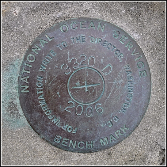
841 3320 TIDAL D
841 3320 TIDAL D
Recovered in Good Condition on September 9, 2012
Spatial/elevation data
| Coordinates | N 44.390933° W 68.202333° |
| Elevation | Unknown |
| Location | Maine
Hancock County Bar Harbor Quad |
Mark description
| Type | Tidal Bench Mark Disk |
| Setting | Rock Outcrop |
| Monumented | 2006 by National Ocean Service |
| Description (National Ocean Service) | The bench mark is a disk set in rock out cropping on the north side of the Bar Harbor Inn and east of the Bar Harbor Inn pier located 32.54 m (106.8 ft) east the center line of the Bar Harbor Inn pier, 13.40 m (44.0 ft) NW of the east end of the stone sea wall running east and west in front to the Bar Harbor Inn, 5.61 m (18.4 ft) north of the centerline of the east end of short stone sea wall almost level with the ground, 0.80 m (2.6 ft) below gravel walking path on the north side of Bar Harbor Inn running east and west along sea wall set in rock out cropping on the north side of sea wall. |
Narrative and photographs
After enjoying some artichoke pockets from Morning Glory Bakery for our breakfast, we took some time to document this mark, disk “D” in the 841 3320 TIDAL series. It’s located on a ledge adjacent to the Shore Path, and directly across the path from the Bar Harbor Inn. This is a beautiful spot for a benchmark with the hotels and trail on one side and the bay on the other! The disk is in very good condition.


