BASS HARBOR RESET (PE1836)
BASS HARBOR RESET
Spatial/elevation data
| Coordinates | N 44.2244° W 68.334983° |
| Elevation | 121 ft. |
| Location | Maine
Hancock County Bass Harbor Quad |
Mark description
| Type | Copper Bolt |
| Setting | Bedrock |
| Monumented | 1902 by NGS |
| Description (NGS) | NGS Datasheet |
NGS recovery information
Descriptive text
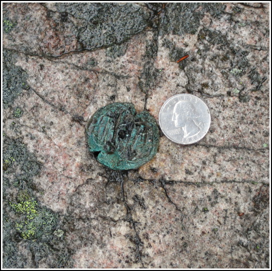
The station and reference marks 1 and 2 were recovered in good condition. It appears that the 1934 recovery note is in error. The station mark is a copper bolt, not a standard disk. The marks are in an area that is now wooded and is part of Acadia National Park. Handheld GPS coordinates for RM 1 are 44 13 27.8(N) 068 20 06.4(W). Handheld GPS coordinates for RM 2 are 44 13 28.3(N) 068 20 06.2(W).Narrative and photographs
For two years Rich and I have been interested in searching for BASS HARBOR RESET, located not coincidentally near Bass Harbor Head Lighthouse (an NGS landmark station). Little did we know how unusual the find would be!
We, along with another geocacher, noticed that the available aerial photos of the area show a rather distinct trail or old road heading nearly directly east toward the tri-station from the road to Bass Harbor Head lighthouse. Before heading out, Rich and I had used USAPhotoMaps to find coordinates for the apparent intersection of the trail and the road. At the site, though, wandering around in the mist, we couldn’t find a single access point or even any indication of an old road. We find this strange because the aerial photo is just over 10 years old.
The only hint of a trail we found (and promptly lost) began at the lighthouse parking area. We entered the woods and headed northeast on this trail and then bushwhacked toward the coordinates. There is a small network of unofficial trails in this area that helped us along our way to some degree.
The woods were incredibly thick with pine, blueberry and other scratchy scrub trees which cut us up as we picked our way toward the coordinates. Eventually we reached an area clear of trees, although we were still waist deep in scrub. Small rock outcroppings appeared here and there, and though it took us a while to zero in on the station bolt, we eventually found it just a few feet from a large pile of rocks.
The reference marks soon followed, fortunately, because by this point the mist had turned to a heavy sprinkle, and all our equipment was getting wet. We measured and photographed, and then picked our way back out through the moist mossy gnarled woods.
Now the situation became even more confusing as we tried to reconcile what we had found with the datasheet descriptions. The 1934 recovery note indicates that the station is a "standard bronze disk." The designation indicates that this disk is likely a reset of the original bolt. However, the bolt is still obviously in place, we found it at the datasheet coordinates, and the arrows on both reference mark disks point toward it. In an attempt to see if a disk might have been set nearby, we cleared a circle of at least a three foot radius around the bolt. We found nothing. We are of course wondering why, if the station was reset, the original bolt would not have been destroyed. And of course, we would like to be able to find the station disk if it does exist!
I contacted Dave Doyle, NGS Chief Geodesist, to see if he could offer a hypothesis. His response was:
Regrettably, I am unable to find any additional information about this station that would shed any light on why you found the original copper bolt and not a disk. I did find some other info that I will need to update the database. The station was original establish in 1863, not 1902 as the datasheet would imply. The station is described on page 218 of Coast & Geodetic Survey Special Publication 46 “Triangulation in Maine)”. I wish I could have found some info that would help solve this little mystery.
So for now, at least, it does remain a mystery.


| Designation | Status | Condition | Image |
|---|---|---|---|
| BASS HARBOR RESET RM 1 | Recovered | Good |
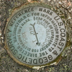
|
| BASS HARBOR RESET RM 2 | Recovered | Good |
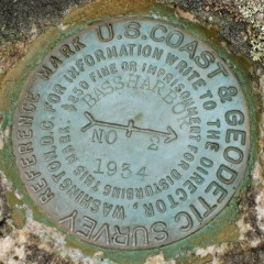
|