Skip to content
Zhanna's SurveyStation
Menu
About
Recoveries
NGS Reports
USGS Reports
Search Recoveries
Map of Recoveries
Browse By Year
Local Databases
USGS Datasheets
Airway Beacons
About Airway Beacons
Eastern U.S.
Western U.S.
Map of Airway Beacons
Historical Airway Maps
Resources
Contact
Zhanna's SurveyStation
Menu
About
Recoveries
NGS Reports
USGS Reports
Search Recoveries
Map of Recoveries
Browse By Year
Local Databases
USGS Datasheets
Airway Beacons
About Airway Beacons
Eastern U.S.
Western U.S.
Map of Airway Beacons
Historical Airway Maps
Resources
Contact
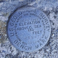
Location:
Wyoming County
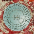
43 CH
USGS
Bench Mark Disk
Pennsylvania
Wyoming County
Noxen Quad
1 AMD
USGS
Bench Mark Disk
Pennsylvania
Wyoming County
Noxen Quad
AMD 3 1942 RESET 1958
USGS
Bench Mark Disk
Pennsylvania
Wyoming County
Noxen Quad
3 AMD
USGS
Bench Mark Disk
Pennsylvania
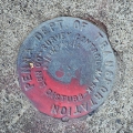
Wyoming County
Noxen Quad
98-65-0292-1
PennDOT
Survey Control Mark
Pennsylvania
Wyoming County
Noxen Quad
38 B
USGS
Bench Mark Disk
Pennsylvania
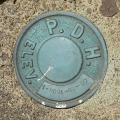
Wyoming County
Noxen Quad
09-65-1005-1
PA Dept. of Highways
Unspecified Disk
Pennsylvania
Wyoming County
Tunkhannock Quad
G 58
NGS
Bench Mark Disk
Pennsylvania
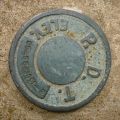
Wyoming County
Tunkhannock Quad
05-65-3001-3
PennDOT
Elevation Mark
Pennsylvania
Wyoming County
Laceyville Quad
N 53
NGS
Bench Mark Disk
Pennsylvania
Wyoming County
Laceyville Quad
Older posts
Page
1
Page
2
…
Page
6
Next
→