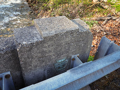
3 AMD
Spatial/elevation data
| Coordinates | N 41.45807° W 76.02854° (estimate) |
| Elevation | 813.919 ft. |
| Location | Pennsylvania
Wyoming County Noxen Quad |
Mark description
| Type | Bench Mark Disk |
| Setting | Bridge Wingwall |
| Monumented | 1942 by USGS |
| Description (USGS) | Noxen, 4.6 mi E. of, along State Highway 29; at bridge over Roaring Run; 19 ft N. of rd.; in N. wingwall; standard tablet stamped “3 AMD 1942 814” Reference mark; 60 ft S. of tablet; in S. wingwall of bridge; PDH standard disk not stamped |
Narrative and photographs
This was the second of two USGS marks I’d hoped to find on my way to the annual Death Hike (held this year at Ricketts Glen State Park). When I arrived and saw the style of the bridge, I had some hope, but unfortunately this bridge was replaced in 1957 and the USGS mark, set in 1942, went away with the old bridge.
I was pleased, however, to see that USGS had reset the mark (see AMD 3 RESET 1958) in 1958, in the same location.

