Skip to content
Zhanna's SurveyStation
Menu
About
Recoveries
NGS Reports
USGS Reports
Search Recoveries
Map of Recoveries
Browse By Year
Local Databases
USGS Datasheets
Airway Beacons
About Airway Beacons
Eastern U.S.
Western U.S.
Map of Airway Beacons
Historical Airway Maps
Resources
Contact
Zhanna's SurveyStation
Menu
About
Recoveries
NGS Reports
USGS Reports
Search Recoveries
Map of Recoveries
Browse By Year
Local Databases
USGS Datasheets
Airway Beacons
About Airway Beacons
Eastern U.S.
Western U.S.
Map of Airway Beacons
Historical Airway Maps
Resources
Contact
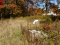
Location:
Clifford Quad
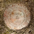
TT 76 TH
USGS
Transit Traverse Station Disk
Pennsylvania
Susquehanna County
Clifford Quad
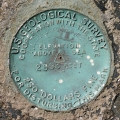
30 ETL
USGS
Bench Mark Disk
Pennsylvania
Susquehanna County
Clifford Quad
34 ETL
USGS
Bench Mark Disk
Pennsylvania
Susquehanna County
Clifford Quad
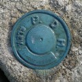
96-57-2008-1
PA Dept. of Highways
Survey Mark
Pennsylvania
Susquehanna County
Clifford Quad
ELK MOUNTAIN RAD E MAST 1959
NGS
Landmark/Intersection Station
Pennsylvania
Susquehanna County
Clifford Quad
ELK MOUNTAIN LOT 1959
NGS
Landmark/Intersection Station
Pennsylvania
Susquehanna County
Clifford Quad
TT 24 A USGS 1942
USGS
Transit Traverse Station Disk
Pennsylvania
Susquehanna County
Clifford Quad
ELK 2
NGS
Triangulation Station Disk
Pennsylvania
Susquehanna County
Clifford Quad
ELK MTN TENN GAS CO MAST 1959
NGS
Landmark/Intersection Station
Pennsylvania
Susquehanna County
Clifford Quad