Skip to content
Zhanna's SurveyStation
Menu
About
Recoveries
NGS Reports
USGS Reports
Search Recoveries
Map of Recoveries
Browse By Year
Local Databases
USGS Datasheets
Airway Beacons
About Airway Beacons
Eastern U.S.
Western U.S.
Map of Airway Beacons
Historical Airway Maps
Resources
Contact
Zhanna's SurveyStation
Menu
About
Recoveries
NGS Reports
USGS Reports
Search Recoveries
Map of Recoveries
Browse By Year
Local Databases
USGS Datasheets
Airway Beacons
About Airway Beacons
Eastern U.S.
Western U.S.
Map of Airway Beacons
Historical Airway Maps
Resources
Contact
Location:
Susquehanna County
TT 76 TH
USGS
Transit Traverse Station Disk
Pennsylvania
Susquehanna County
Clifford Quad
TT STA NO 77 TH
USGS
Transit Traverse Station Disk
Pennsylvania
Susquehanna County
Forest City Quad
30 ETL
USGS
Bench Mark Disk
Pennsylvania
Susquehanna County
Clifford Quad
34 ETL
USGS
Bench Mark Disk
Pennsylvania
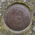
Susquehanna County
Clifford Quad
E 400
NGS
Vertical Control Mark
Pennsylvania
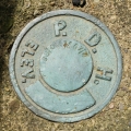
Susquehanna County
Susquehanna Quad
PDH
PA Dept. of Highways
Elevation Mark
Pennsylvania
Susquehanna County
Lenoxville Quad
RESET 1950
USGS
Bench Mark Disk
Pennsylvania
Susquehanna County
Lenoxville Quad
24 ETL
USGS
Bench Mark Disk
Pennsylvania
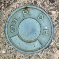
Susquehanna County
Lenoxville Quad
98-0167-57-4
PA Dept. of Highways
Survey Control Mark
Pennsylvania
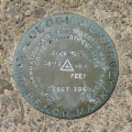
Susquehanna County
Hop Bottom Quad
1 W
USGS
Bench Mark Disk
Pennsylvania
Susquehanna County
Laurel Lake Quad
Older posts
Page
1
Page
2
Page
3
Next
→