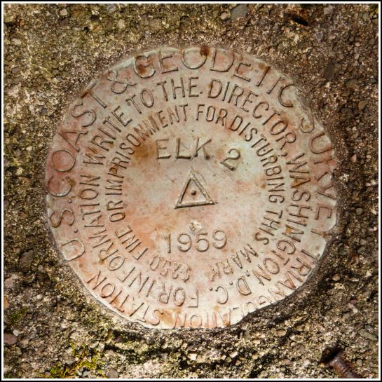
ELK 2 (LY2782)
ELK 2
Spatial/elevation data
| Coordinates | N 41.715284° W 75.560982° |
| Elevation | 2692 ft. |
| Location | Pennsylvania
Susquehanna County Clifford Quad |
Mark description
| Type | Triangulation Station Disk |
| Setting | Square Concrete Monument |
| Monumented | 1959 by NGS |
| Description (NGS) | NGS Datasheet |
NGS recovery information
Descriptive text
The station and reference mark 1 (USGS mark TT 24 A 1929) were recovered in good condition. Reference mark 3 was not found but it is likely still in place, below the ground surface. The area is now part of Elk Mountain Ski Resort. The azimuth mark was not searched for at this time.Narrative and photographs
For a few years, we’ve been aware that there are (or are supposed to be) some survey marks atop Elk Mountain, which in winter is a reasonably well-regarded ski resort. Of course, whenever I’ve been there to ski, any survey marks would have been snow covered and completely inaccessible. Elk’s Fall Festival, a celebration of the mountain held each October, provided a perfect opportunity to enjoy the mountain in a different season by riding the lift to the top and hiking around in search of the triangulation station and TT station, and trying to make some sense of the history of the various radio towers.
We found the station mark quite easily. It is in excellent condition in a square concrete monument. As we’ve seen before, the monument held two nails (one of which is missing, but the impression remains) pointing in the direction of the reference marks. A witness post clearly indicates that a station is nearby. Perhaps it was installed following the destruction of the original set of marks (ELK - LY2785) when the radio masts were constructed.
We found RM 1, which is also the USGS transit traverse station TT 24 A, set into a concrete slab nearby. The description of both marks explains that this slab was originally the bottom step of the set of stairs leading to the top of the fire lookout tower, which is now destroyed. (The tower was also an NGS station.) I’m not going to list it as RM 1 for this station since it is logged separately.
We were unable to find RM 3, probably because the bedrock into which it’s set was two inches below ground surface in 1959. By now it may be significantly lower and may require a metal detector (and some more privacy than we had today) to locate. We also didn’t have an opportunity to look for the azimuth mark, but our calculations place it near 41.720133,-75.584549, just NW of Route 374.


