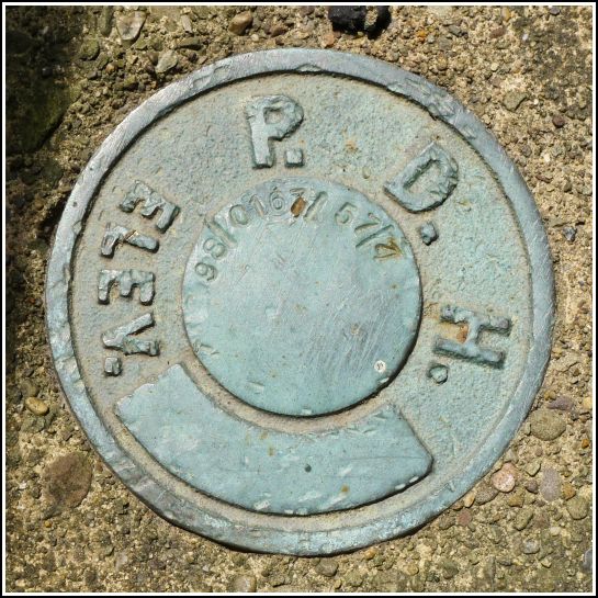
98-0167-57-4
98-0167-57-4
Spatial/elevation data
| Coordinates | N 41.70539° W 75.76728° |
| Elevation | Unknown |
| Location | Pennsylvania
Susquehanna County Hop Bottom Quad |
Mark description
| Type | Survey Control Mark |
| Setting | Bridge Wingwall |
| Monumented | 1998? by PA Dept. of Highways |
| Description (PA Dept. of Highways) | Unavailable. |
Narrative and photographs
As we approached the Route 167 bridge in Hop Bottom, it occurred to me that I had never checked it for any survey marks, so this time, we checked. Dad and I found an old PDH disk set into the northeast wingwall. Often these PDH disks are unstamped or were at some point in the 1960s stamped by USGS. In this case, the stamping was the newer style that we’ve been finding on the new PennDOT disks. We noticed that the stamping is in a slightly different order than all of the other PennDOT marks of this type (year - route - county - number rather than year - county - route - number). I assume it’s just a simple error. The disk itself is in good condition.
A car stopped while Dad and I were looking at the mark. An older man got out and, to our surprise, didn’t ask what we were doing but asked if we knew anything about Hop Bottom. “Well, yeah,” Dad said, “I grew up here.” “Well, then you’re just the person I want to talk to!” the man said. He went on to ask where he could find the old Dairylea Creamery. He had worked for Dairylea in New York (Bronx, I think) and always knew about the Hop Bottom creamery. Now that he, for whatever reason, found himself in the area, he thought he’d see if he could find the building. Not much is left, but Dad explained how to get to the spot. The man then went on to explain how he had worked for several large food companies, including Chef Boyardee, throughout his career.


