Skip to content
Zhanna's SurveyStation
Menu
About
Recoveries
NGS Reports
USGS Reports
Search Recoveries
Map of Recoveries
Browse By Year
Local Databases
USGS Datasheets
Airway Beacons
About Airway Beacons
Eastern U.S.
Western U.S.
Map of Airway Beacons
Historical Airway Maps
Resources
Contact
Zhanna's SurveyStation
Menu
About
Recoveries
NGS Reports
USGS Reports
Search Recoveries
Map of Recoveries
Browse By Year
Local Databases
USGS Datasheets
Airway Beacons
About Airway Beacons
Eastern U.S.
Western U.S.
Map of Airway Beacons
Historical Airway Maps
Resources
Contact
Location:
Pike County
210 LRP
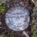
USGS
Bench Mark Disk
Pennsylvania
Pike County
Narrowsburg Quad
211 LRP
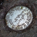
USGS
Bench Mark Disk
Pennsylvania
Pike County
Narrowsburg Quad
212 LRP
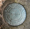
USGS
Bench Mark Disk
Pennsylvania
Pike County
Damascus Quad
213 LRP
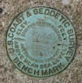
USGS
Bench Mark Disk
Pennsylvania
Pike County
Narrowsburg Quad
TEDY RM 2
NGS
Reference Mark Disk
Pennsylvania
Pike County
Narrowsburg Quad
TEDY RM 1
NGS
Reference Mark Disk
Pennsylvania
Pike County
Narrowsburg Quad
TEDY
NGS
Triangulation Station Disk
Pennsylvania
Pike County
Narrowsburg Quad
Z 235
NGS
Bench Mark Disk
Pennsylvania
Pike County
Hawley Quad
Q 50 RESET 1944
Erie Lackawanna Railroad
Bench Mark Disk
Pennsylvania
Pike County
Rowland Quad
212 LRP
USGS
Bench Mark Disk
Pennsylvania
Pike County
Damascus Quad
Older posts
Page
1
Page
2
…
Page
9
Next
→