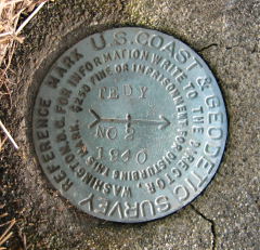
TEDY (LY2668)
TEDY
Spatial/elevation data
| Coordinates | N 41.501883° W 75.10235° |
| Elevation | 1362 ft. |
| Location | Pennsylvania
Pike County Narrowsburg Quad |
Mark description
| Type | Triangulation Station Disk |
| Setting | Square Concrete Monument |
| Monumented | 1940 by NGS |
| Description (NGS) | NGS Datasheet |
NGS recovery information
Descriptive text
Mark not found. Coordinates and measurements indicate that the station lies beneath a bank of fill at a construction site along Route 590. Reference mark 1 not found. Reference mark 2 still exists, but its monument has been damaged and now lies at an angle in the ground.Narrative and photographs
While in Pike County on a mission to check on Z 235 (LY1235), Rich and I decided to look for TEDY. We were expecting an easy and interesting find because our maps indicated that this mark lies within “Forest Lake Park.” To our disappointment and slight confusion, when we arrived we discovered that the park is no longer a park (or at least is not publicly accessible), and that this stretch along the highway is currently undergoing construction.
Coordinates for the station mark took us directly on top of a high bank of fill between the highway and construction trailers. The mark may well still exist, but it is completely inaccessible at the moment. We believe we found the boulder that once held RM1, but no mark was evident. Either it is buried, or the part of the boulder holding the mark has been broken off. RM2 was found, but the concrete monument into which it is set is damaged. It looks to have been hit by a plow or other heavy equipment and now lies at an angle.


| Designation | Status | Condition | Image |
|---|---|---|---|
| TEDY RM 1 | Not Found | Unknown (Not Found) |

|
| TEDY RM 2 | Recovered | Poor |
|