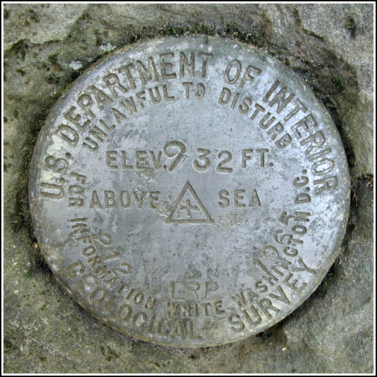
212 LRP
Spatial/elevation data
| Coordinates | N 41.55598° W 75.07812° |
| Elevation | 932 ft. |
| Location | Pennsylvania
Pike County Damascus Quad |
Mark description
| Type | Bench Mark Disk |
| Setting | Boulder |
| Monumented | 1965 by USGS |
| Description (USGS) | Mast Hope, 3.0 mi W. of; 300 ft N. of centerline of rd. at junction of drive N. to house of Mr. Badenhausen; 20 ft N. and 16 ft W. of, and 1.3 ft lower than center of bridge at stream crossing; in top of large boulder; standard tablet stamped “212 LRP 1965 932” |
USGS recovery information
View reportNarrative and photographs
On our first trip to SGL#316, we planned to try for a First Find on a new geocache (GC5A04 Requirement Cache) as well as to look for this benchmark and just explore the area in general. We saw only a small section of this gamelands, but it’s beautiful! Long trails wind through evergreen forests and around a pretty lake surrounded by berry bushes (and through one grassy clear-cut area filled with ticks—I’ll avoid that spot on future visits). Several of the trails are open to biking so we’ll return with our bikes next time and explore further.
Today we headed to the geocache first, passing by the benchmark on the way and confirming its existence. Then on our way back to the car to grab our equipment for the rest of the day, we stopped to recover the mark.
The mark is set in a sloping boulder just below the northwest corner of the bridge. It is in good condition and doesn’t appear to have been disturbed. The aluminum disk is in good shape with light, but clear stamping.This land was once privately owned by a man eventually convicted of serious drug trafficking violations. His property was forfeited and is now operated as a State Game Land. I have to wonder if the “Mr. Badenhausen” mentioned in the description might have been the culprit, or just a previous landowner.


