Skip to content
Zhanna's SurveyStation
Menu
About
Recoveries
NGS Reports
USGS Reports
Search Recoveries
Map of Recoveries
Browse By Year
Local Databases
USGS Datasheets
Airway Beacons
About Airway Beacons
Eastern U.S.
Western U.S.
Map of Airway Beacons
Historical Airway Maps
Resources
Contact
Zhanna's SurveyStation
Menu
About
Recoveries
NGS Reports
USGS Reports
Search Recoveries
Map of Recoveries
Browse By Year
Local Databases
USGS Datasheets
Airway Beacons
About Airway Beacons
Eastern U.S.
Western U.S.
Map of Airway Beacons
Historical Airway Maps
Resources
Contact
Location:
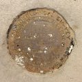
Carbon County
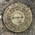
75 C
USGS
Bench Mark Disk
Pennsylvania
Carbon County
Blakeslee Quad
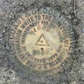
13-06 12 A
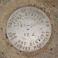
County of Carbon
GPS Survey Monument
Pennsylvania
Carbon County
Weatherly Quad
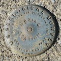
F 48
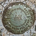
NGS
Bench Mark Disk
Pennsylvania
Carbon County
Christmans Quad
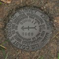
HICKORY RM 2
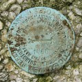
NGS
Reference Mark Disk
Pennsylvania
Carbon County
Hickory Run Quad
HICKORY RM 1
NGS
Reference Mark Disk
Pennsylvania
Carbon County
Hickory Run Quad
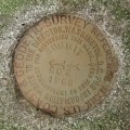
HICKORY
NGS
Triangulation Station Disk
Pennsylvania
Carbon County
Hickory Run Quad
SWITCHBACK CHIM MT JEFFERSON
NGS
Landmark/Intersection Station
Pennsylvania
Carbon County
Nesquehoning Quad
USGS GAGING STATION 01449800
USGS
Gaging Station Disk
Pennsylvania
Carbon County
Lehighton Quad
SUMMIT AZ MK
NGS
Azimuth Mark Disk
Pennsylvania
Carbon County
Nesquehoning Quad
SUMMIT RM 2
NGS
Reference Mark Disk
Pennsylvania
Carbon County
Nesquehoning Quad
Older posts
Page
1
Page
2
…
Page
4
Next
→