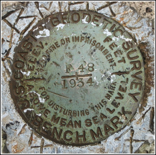
F 48 (KV2763)
F 48
Spatial/elevation data
| Coordinates | N 40.945033° W 75.7466° |
| Elevation | 726.67 ft. |
| Location | Pennsylvania
Carbon County Christmans Quad |
Mark description
| Type | Bench Mark Disk |
| Setting | Bridge Abutment |
| Monumented | 1934 by NGS |
| Description (NGS) | NGS Datasheet |
NGS recovery information
Descriptive text
Recovered in good condition. The track is now owned by the Reading Blue Mountain and Northern Railroad. Handheld GPS WAAS-corrected coordinates for the mark are 40 56 42.1(N) 075 44 47.8(W).Narrative and photographs
Rich and I spent this lovely late-Summer day (well, at least the first half was lovely) on a leisurely ride along the northern section of the Lehigh Gorge Trail. We had originally planned to ride from White Haven only to Rockport, which in hindsight probably would have been a better idea given the horrendous weather conditions we encountered later in the afternoon. But we were still feeling strong and ambitious upon reaching Rockport, so we decided to continue on southward to the next interesting feature on the map: Penn Haven Junction.
The sun had been in and out of the clouds all day, but when we reached the open area at the Penn Haven railroad crossing, it was brilliantly sunny and warm. Rich chilled out on the crumbling concrete steps below one of the active rail lines while I poked around on the nearby railroad bridges, hoping to spot a benchmark on one of the abutments. There are two bridges at the junction; one is now utilized by the rail-trail and the other still carries active track across the river. I was pleased, though not terribly surprised, to find “F 48” set in the south abutment of the bridge on the active line.


