Skip to content
Zhanna's SurveyStation
Menu
About
Recoveries
NGS Reports
USGS Reports
Search Recoveries
Map of Recoveries
Browse By Year
Local Databases
USGS Datasheets
Airway Beacons
About Airway Beacons
Eastern U.S.
Western U.S.
Map of Airway Beacons
Historical Airway Maps
Resources
Contact
Zhanna's SurveyStation
Menu
About
Recoveries
NGS Reports
USGS Reports
Search Recoveries
Map of Recoveries
Browse By Year
Local Databases
USGS Datasheets
Airway Beacons
About Airway Beacons
Eastern U.S.
Western U.S.
Map of Airway Beacons
Historical Airway Maps
Resources
Contact
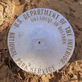
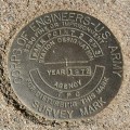
Location:
Montezuma County
A 49
National Park Service
Survey Mark
Colorado
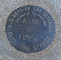
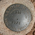
Montezuma County
Moccasin Mesa Quad
A 46
National Park Service
Survey Mark
Colorado
Montezuma County
Moccasin Mesa Quad
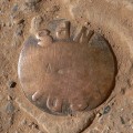
A 1
National Park Service
Survey Mark
Colorado
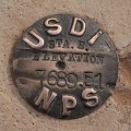
Montezuma County
Moccasin Mesa Quad
7689.51
National Park Service
Elevation Mark
Colorado
Montezuma County
Weatherill Mesa Quad
NPS (Unstamped, Mesa Verde #1)
National Park Service
Unspecified Disk
Colorado
Montezuma County
Weatherill Mesa Quad
PARK POINT 2 RM 3
Defense Map Agency
Survey Mark
Colorado
Montezuma County
Point Lookout Quad
PARK POINT 2 RM 2
NGS
Reference Mark Disk
Colorado
Montezuma County
Point Lookout Quad
PARK POINT 2 RM 1
NGS
Reference Mark Disk
Colorado
Montezuma County
Point Lookout Quad
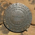
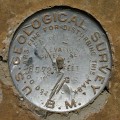
PARK POINT 8572.3
USGS
Bench Mark Disk
Colorado
Montezuma County
Point Lookout Quad
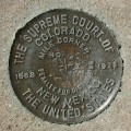
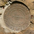
BOUNDARY MI COR 330 CO NM
U.S. Supreme Court
Boundary Monument
Colorado
Montezuma County
Teec Nos Pos Quad
Older posts
Page
1
Page
2
Next
→