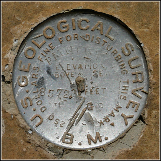
PARK POINT 8572.3 (HM0504)
PARK POINT 8572.3
Spatial/elevation data
| Coordinates | N 37.280666° W 108.461483° |
| Elevation | 8576.4 ft. |
| Location | Colorado
Montezuma County Point Lookout Quad |
Mark description
| Type | Bench Mark Disk |
| Setting | Boulder |
| Monumented | 1934 by USGS |
| Description (NGS) | NGS Datasheet |
Narrative and photographs
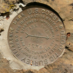
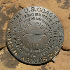
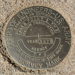
The drive to Park Point Lookout was our first encounter with the awe-inspiring views of Mesa Verde. We of course had to mark the occasion with a few benchmark recoveries! The disks were all easy finds, but there is a strange intermingling in the histories of the two marks (PIDs HM0504 and this mark, HM0505) at Park Point. The station disk for this PID, HM0505, has the name PARK POINT 2 RM 3, which would imply that there is a reset disk named PARK POINT 2, but there does not seem to be one. The only other station mentioned is PARK POINT 8572.31.
This station has an RM 1 listed in its description; is it the same RM 1 that belongs to HM0505? RM 2 for this station is actually the station disk HM0504. It is not at all clear which RMs actually belong to which station. I have described both RMs and provided photos on my page for HM0504: PARK POINT 8572.3. As seventhings said in his Geocaching.com log for this mark, “I found PARK POINT, and two RMs for something.”
On our slow drive back down the mountain, we searched quite carefully for but could not locate the azimuth mark, nor the culvert on which it had been set.

 in proximity to the fire lookout station.")


| Designation | Status | Condition | Image |
|---|---|---|---|
| PARK POINT 2 RM 1 | Recovered | Good |
|
| PARK POINT 2 RM 2 | Recovered | Good |
|
| PARK POINT 2 RM 3 | Recovered | Good |
|