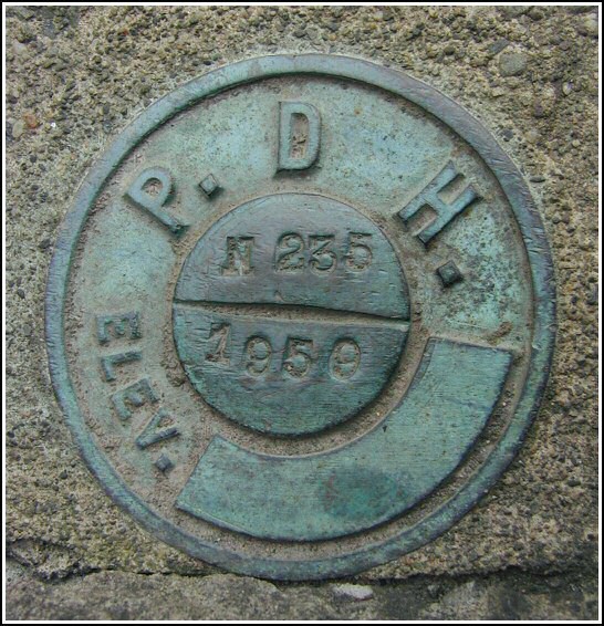
N 235 (LY1226)
N 235
Spatial/elevation data
| Coordinates | N 41.3728° W 75.128016° |
| Elevation | 1394.28 ft. |
| Location | Pennsylvania
Pike County Promised Land Quad |
Mark description
| Type | Survey Mark |
| Setting | Bridge Wingwall |
| Monumented | 1959 by PA Dept. of Highways |
| Description (NGS) | NGS Datasheet |
NGS recovery information
Descriptive text
Mark recovered in good condition. The bridge crosses Blooming Grove Creek, not Egypt Creek as is mentioned in the 1959 description.Narrative and photographs
Our final find for today was a challenge to photograph. I’d avoided it on previous excursions due to its proximity to rushing traffic and the fact that there’s very little room to stand next to the bridge, atop the steep bank down to Blooming Grove Creek (not Egypt Creek). Today, Rich and I were ready. We parked at the Good Shepherd Church, walked to the bridge and hopped over the guard rail. Recovering the mark was easier than I’d expected, but I did need to hang onto a sign post while stretching my other arm in front of me to take a photo of the mark. This Pennsylvania Department of Highways vertical control station was found in good condition as described, with the exception of the discrepancy over the name of the creek.


Recovered in good condition.
This second order vertical control station is set in the top of the east wingwall for the south abutment of a concrete bridge on Rt. 402 crossing Blooming Grove Creek. The 1959 historical description leads reliably to the station. At the station a Garmin GPSmap76 receiver with remote active antenna was used to record WAAS-corrected coordinates which were 12.2 feet from the scaled coordinates listed in the NGS datasheet. The mark is well exposed, in good condition, and the stamped designation is legible.
~Rich in NEPA~


