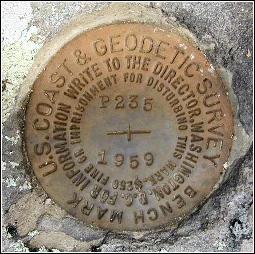
P 235 (LY1224)
P 235
Spatial/elevation data
| Coordinates | N 41.358716° W 75.128366° |
| Elevation | 1513.72 ft. |
| Location | Pennsylvania
Pike County Promised Land Quad |
Mark description
| Type | Bench Mark Disk |
| Setting | Boulder |
| Monumented | 1959 by NGS |
| Description (NGS) | NGS Datasheet |
NGS recovery information
Descriptive text
The station mark was found in good condition. The dim trail road and powerpole X 15 were not found, but the mark was measured to be approximately 58 feet east of the centerline of Route 402. The station is east of a point between two powerpoles that are 353 feet apart along the west shoulder of the highway: this point is 171 feet south along the shoulder from powerpole PPL Co. 71943 N44506, and 182 feet north along the shoulder from powerpole PPL Co. 71941 N44471.Narrative and photographs
Continuing to search for marks in the 235 series, we worked our way north on Route 402 to search for P 235. This was a relatively straightforward find, although several references on the datasheet needed to be corrected. We had plenty of measuring ahead of us! The “dim trail road” mentioned in the 1959 note can no longer be discerned, so we measured a perpendicular distance from the road centerline to the mark. That distance was found to be about 58 feet. We also were unable to find a powerpole marked “X 15” (indeed, there is no longer any pole where “X 15” is described to have been). We did find two marked poles on the western shoulder of Route 402, one north of the mark and one south, that could be used for rough measurements. We measured the distance between each pole and the point on the line between the poles directly west of the mark; measurements are given below. I was excited to find the letters “BM” painted on a tree just a few feet from the mark!


.")
.")
Recovered in good condition.
This second order vertical control station is set in the top of an outcropping boulder roughly 58 feet east of the centerline of Rt. 402, about level with the blacktop, and about 1 foot above ground level. In addition, it is east of a point between two powerpoles that are 353 feet apart along the west shoulder of the highway. This point is roughly 171 feet south along the shoulder from powerpole number: PP&L Co. 71943 N44506, and roughly 182 feet north along the shoulder from powerpole number: PP&L Co. 71941 N44471. The dim trail road referred to in the 1959 historical description could not be discerned. At the station a Garmin GPSmap76 receiver with remote active antenna was used to record WAAS-corrected coordinates which were 40.8 feet from the scaled coordinates listed in the NGS datasheet. The mark is well exposed, in good condition, and the stamped designation is legible.
~Rich in NEPA~


