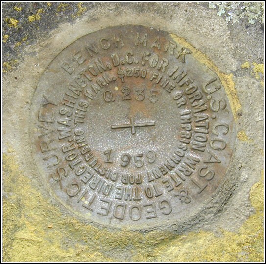
Q 235 (LY1154)
Q 235
Spatial/elevation data
| Coordinates | N 41.3466° W 75.13115° |
| Elevation | 1562.24 ft. |
| Location | Pennsylvania
Pike County Promised Land Quad |
Mark description
| Type | Bench Mark Disk |
| Setting | Boulder |
| Monumented | 1959 by NGS |
| Description (NGS) | NGS Datasheet |
NGS recovery information
Descriptive text
Mark recovered in good condition. It is located approximately 71 feet east, not west, of the centerline of PA Route 402, and is set in a ledge near the south end of a boulder. The mark is 2-1/2 feet above ground level and is approximately level with the highway. The mark is on property owned by the Blooming Grove Hunting and Fishing Club. Contact information - Scott F. Savini, General Manager; HC 8 Box 8066, Hawley, PA 18428; 570-775-7371.Narrative and photographs
After digging unsuccessfully for LY2678 RM2 nearby at High Knob, Rich and I decided to work some more on the 235 series. Q 235 sounded like an easy one; we figured it would be hard to miss a 24’ x 18’ boulder. When we stopped at the woods road leading west from the highway, though, we saw no evidence of a boulder of that size. We noticed that the description mentioned a “track road east” rather than west, so we crossed the highway to search. The boulder and mark were then found immediately. We concluded that the description is in error and should state that the mark is east of the highway, not west. The mark is in good condition with all stamping legible. Before leaving the area, we took some measurements to document the mark’s current distance from the highway centerline, height off the ground in the area of the boulder, and height relative to the level of the highway.


N 41° 20.792’ W 075° 07.875’
Recovered in good condition.
This second order vertical control station is set in a “ledge” at the south end of an outcropping boulder, about 9 feet north of a track road, about 2½ feet above ground level, and on property owned by the Blooming Grove Hunting & Fishing Club. The historical description is in error since the station is not west of Rt. 402 but is roughly 71 feet east of the centerline of the highway, and at about the same level as the blacktop. At the station a Garmin GPSmap76 receiver with remote active antenna was used to record autonomous (non-corrected) coordinates which were 65.8 feet from the scaled coordinates listed in the NGS datasheet. The mark is well exposed, in good condition, and the stamped designation is legible.
~Rich in NEPA~


