Skip to content
Zhanna's SurveyStation
Menu
About
Recoveries
NGS Reports
USGS Reports
Search Recoveries
Map of Recoveries
Browse By Year
Local Databases
USGS Datasheets
Airway Beacons
About Airway Beacons
Eastern U.S.
Western U.S.
Map of Airway Beacons
Historical Airway Maps
Resources
Contact
Zhanna's SurveyStation
Menu
About
Recoveries
NGS Reports
USGS Reports
Search Recoveries
Map of Recoveries
Browse By Year
Local Databases
USGS Datasheets
Airway Beacons
About Airway Beacons
Eastern U.S.
Western U.S.
Map of Airway Beacons
Historical Airway Maps
Resources
Contact
Location:
Castine Quad
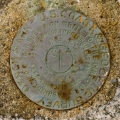
TIDAL 30 STA 30
NGS
Tidal Bench Mark Disk
Maine
Waldo County
Castine Quad
TIDAL 2 STA 30
NGS
Tidal Bench Mark Disk
Maine
Waldo County
Castine Quad
D 147
NGS
Bench Mark Disk
Maine
Waldo County
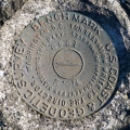
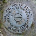
Castine Quad
841 4721 B TIDAL
National Ocean Service
Tidal Bench Mark Disk
Maine
Waldo County
Castine Quad
TIDAL 2 STA 30
NGS
Tidal Bench Mark Disk
Maine
Waldo County
Castine Quad
TIDAL 30 STA 30
NGS
Tidal Bench Mark Disk
Maine
Waldo County
Castine Quad
TIDAL 3 STA 30
NGS
Drill Hole
Maine
Waldo County
Castine Quad
FORT POINT LH
NGS
Landmark/Intersection Station
Maine
Waldo County
Castine Quad
FORT POINT LEDGE BEACON
NGS
Landmark/Intersection Station
Maine
Waldo County
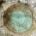
Castine Quad
D 147
NGS
Bench Mark Disk
Maine
Waldo County
Castine Quad
Older posts
Page
1
Page
2
Next
→