TIDAL 2 STA 30 (PE0383)
TIDAL 2 STA 30
Spatial/elevation data
| Coordinates | N 44.470722° W 68.813277° |
| Elevation | 6.95 ft. |
| Location | Maine
Waldo County Castine Quad |
Mark description
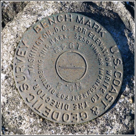
| Type | Tidal Bench Mark Disk |
| Setting | Boulder |
| Monumented | 1948 by NGS |
| Description (NGS) | NGS Datasheet |
NGS recovery information
Descriptive text
The mark was recovered in good condition atop a large boulder on the beach, as described. The property is now part of Fort Point State Park and is open to the public. A new pier has been built near the boulder. The boulder is nearly submerged at high tide but is completely exposed and easily accessible at low tide. Handheld GPS coordinates for the mark are 44 28 14.6(N) 068 48 47.8(W).Narrative and photographs
What a difference a year makes! We attempted to find this mark last year, but arrived at the beach to find that it was high tide and that the only large boulder in sight was surrounded by water. From the nearby pier we could see a round spot on the boulder that appeared to be a disk, but without a boat or the desire to swim in 50° water, neither of which we had, we were unable to recover the mark last year. We really weren’t even sure which tidal BM it was, since the descriptions of the various marks in this area—TIDAL 2, TIDAL 3, and TIDAL 30—are confusing. Our best guess was that this disk was TIDAL 2.
This year we were delighted to see that not only was it low tide at the time of our visit, but that the tide was even lower than we had expected: we could actually walk right out to the boulder and climb on top (well, I could, with some coaxing and major assistance from Rich) to confirm that the mark was indeed TIDAL 2. The disk is in very good condition and is easily accessible at low tide if you’re willing to do a bit of rock scrambling. Just watch out for the slippery seaweed!


