Skip to content
Zhanna's SurveyStation
Menu
About
Recoveries
NGS Reports
USGS Reports
Search Recoveries
Map of Recoveries
Browse By Year
Local Databases
USGS Datasheets
Airway Beacons
About Airway Beacons
Eastern U.S.
Western U.S.
Map of Airway Beacons
Historical Airway Maps
Resources
Contact
Zhanna's SurveyStation
Menu
About
Recoveries
NGS Reports
USGS Reports
Search Recoveries
Map of Recoveries
Browse By Year
Local Databases
USGS Datasheets
Airway Beacons
About Airway Beacons
Eastern U.S.
Western U.S.
Map of Airway Beacons
Historical Airway Maps
Resources
Contact
Location:
Blue Hill Quad
BLUE HILL CONG CHURCH SPIRE
NGS
Landmark/Intersection Station
Maine
Hancock County
Blue Hill Quad
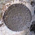
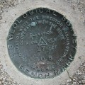
BLUE HILL RM 3
NGS
Reference Mark Disk
Maine
Hancock County
Blue Hill Quad
BLUE HILL RM 2
NGS
Reference Mark Disk
Maine
Hancock County
Blue Hill Quad
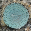
BLUE HILL RM 1
NGS
Reference Mark Disk
Maine
Hancock County
Blue Hill Quad
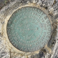
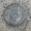
BLUE HILL RESET
NGS
Triangulation Station Disk
Maine
Hancock County
Blue Hill Quad
BLUE HILL LOOKOUT TOWER 1956
NGS
Landmark/Intersection Station
Maine
Hancock County
Blue Hill Quad
10201-11
MaineDOT
Survey Control Mark
Maine
Hancock County
Blue Hill Quad
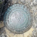
WO 6
USGS
Bench Mark Disk
Maine
Hancock County
Blue Hill Quad