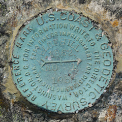
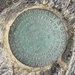
BLUE HILL RESET (PE1962)
BLUE HILL RESET

Spatial/elevation data
| Coordinates | N 44.434002° W 68.590686° |
| Elevation | 922 ft. |
| Location | Maine
Hancock County Blue Hill Quad |
Mark description
| Type | Triangulation Station Disk |
| Setting | Rock Outcrop |
| Monumented | 1862 by NGS |
| Description (NGS) | NGS Datasheet |
NGS recovery information
Descriptive text
The station mark and reference marks 1, 2 and 3 were recovered in good condition on outcropping bedrock as described. The Blue Hill Heritage Trust now owns and manages part of Blue Hill Mountain including the summit, and the property is open to the public. Several hiking trails lead to the summit. The Forest Service lookout tower was dismantled and removed from the site in 2005. Handheld GPS coordinates for RM 1 are 44 26 02.3(N) 068 35 26.9(W). Handheld GPS coordinates for RM 2 are 44 26 02.7(N) 068 35 26.8(W).Narrative and photographs
This is another example of “tiny triangle randomly spotted on a map leads to awesome adventures!” A few months ago, Rich and I happened to see the triangulation station BLUE HILL indicated on an old topo map and wondered how we might access it. We were thrilled to find out that not only are there trails to the summit of Blue Hill Mountain, but they are open to the public and maintained by the Blue Hill Heritage Trust . When we realized that El El Frijoles is only a few miles away, our plans for one of our Maine vacation days began to come together.
We parked in the western, and smaller, of two designated parking areas along Mountain Road. This area is simply a widened shoulder and isn’t visible from the Google satellite view, but when we arrived at the site we found that it was plenty large enough for five or six vehicles. Directly across Mountain Road is the trailhead for the Osgood Trail. We chose this trail because, according to its description on the Blue Hill Heritage Trust’s website, it is an “easy to moderate” climb. Which it mostly is, although we weren’t quite prepared for the rock-and-rootiness of the trail. There were some nicely constructed stone steps (not quite CCC-nice, but still great trail construction for a private group) to take us over the steepest sections. And once we popped out of the dark woods onto the wide open summit ledges—well, the view is worth the work it took to get there and then some.
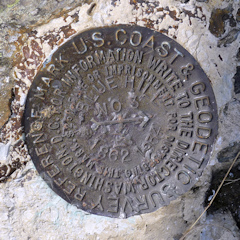
The first disk we found was RM 3, because I’d been navigating toward the location of the old fire tower, and RM 3 was centered directly beneath the tower when it was still here. Next we found the station marker at the base of an obvious pyramidal cairn, and we found the other two reference marks in a matter of minutes simply by wandering the open rock ledge. All marks are in good condition, especially for being in such a popular and exposed location, and stamping is legible. Dad enjoyed the opportunity for a little rest as Rich and I documented all four disks as well as what remains of the fire tower.
After finding a geocache near the summit (with even better views over Blue Hill Bay), we took the Hayes Trail back down to Mountain Road. Past the communications tower, this trail includes a rerouted section through a talus slope (rocky, loose, and challenging) which eventually emerges on another set of well-constructed steps leading down the base of the mountain to the meadow.


| Designation | Status | Condition | Image |
|---|---|---|---|
| BLUE HILL RM 1 | Recovered | Good |
|
| BLUE HILL RM 2 | Recovered | Good |
|
| BLUE HILL RM 3 | Recovered | Good |
|