Skip to content
Zhanna's SurveyStation
Menu
About
Recoveries
NGS Reports
USGS Reports
Search Recoveries
Map of Recoveries
Browse By Year
Local Databases
USGS Datasheets
Airway Beacons
About Airway Beacons
Eastern U.S.
Western U.S.
Map of Airway Beacons
Historical Airway Maps
Resources
Contact
Zhanna's SurveyStation
Menu
About
Recoveries
NGS Reports
USGS Reports
Search Recoveries
Map of Recoveries
Browse By Year
Local Databases
USGS Datasheets
Airway Beacons
About Airway Beacons
Eastern U.S.
Western U.S.
Map of Airway Beacons
Historical Airway Maps
Resources
Contact
Location:
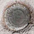
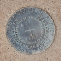
Pima County
Z 110
NGS
Bench Mark Disk
Lukeville Quad
Arizona
Pima County
1670.46
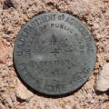
U. S. Department of Agriculture
Survey Disk
Lukeville Quad
Arizona
Pima County
F 471
NGS
Steel Rod
Lukeville Quad
Arizona
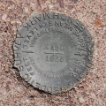
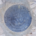
Pima County
X 110
NGS
Bench Mark Disk
Tillotson Peak Quad
Arizona
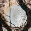
Pima County
Y 110
NGS
Bench Mark Disk
Lukeville Quad
Arizona
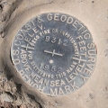
Pima County
B 312
NGS
Bench Mark Disk
Lukeville Quad
Arizona
Pima County
557 32.70
U.S. Bureau of Public Roads
Unspecified Disk
Tillotson Peak Quad
Arizona
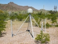
Pima County
ORGAN_PIPEAZ2007 CORS GRP
NGS
CORS Station
Lukeville Quad
Arizona
Pima County
A 471
NGS
Vertical Control Mark
Tillotson Peak Quad
Arizona
Pima County
A 312
NGS
Bench Mark Disk
Lukeville Quad
Arizona
Pima County
Older posts
Page
1
Page
2
…
Page
9
Next
→