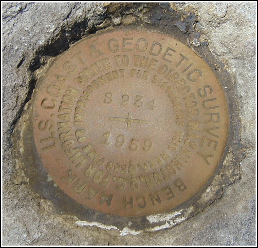
S 234 (LY1171)
S 234
Spatial/elevation data
| Coordinates | N 41.348616° W 75.21275° |
| Elevation | 1772.02 ft. |
| Location | Pennsylvania
Pike County Promised Land Quad |
Mark description
| Type | Bench Mark Disk |
| Setting | Boulder |
| Monumented | 1959 by NGS |
| Description (NGS) | NGS Datasheet |
NGS recovery information
Descriptive text
Recovered in good condition. Shiney Mt. Road forms the Y intersection with Route 390. Handheld GPS WAAS-corrected coordinates for the station are 41 20 55.02(N) 075 12 45.90(W).Narrative and photographs
Our main adventure for the morning was a scenic hike along beautiful Wallenpaupack Creek, during which we found the Little Falls Cache. On our way home, we decided to extend our morning’s adventures by searching for a few benchmarks along Route 390. This mark was easy to locate using the historic description, which remains accurate. Our only additional observation was that the “blacktop road” forming the Y intersection with Route 390 is named Shiney Mt. Road, according to the sign at the intersection. Distances and directions to the reference objects matched those given in the 1959 description. The mark is in good condition.


N 41° 20.917’ W 075° 12.765’
Recovered in good condition.
This second order vertical control station was found as described. The historical direction is still viable. Shiney Mt. Road forms the Y-intersection with Rt. 390. At the station a Garmin GPSmap76 receiver with remote active antenna was used to record WAAS-corrected coordinates which were 68.5 feet from the scaled coordinates listed in the NGS datasheet. The mark is well exposed, in good condition, and the stamped designation is legible.
~Rich in NEPA~


