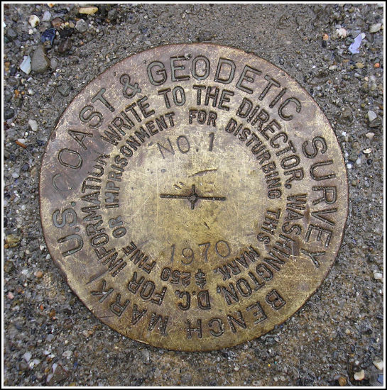
841 3320 TIDAL 1 (AI8315)
841 3320 TIDAL 1
Spatial/elevation data
| Coordinates | N 44.392167° W 68.2038° |
| Elevation | 10.75 ft. |
| Location | Maine
Hancock County Bar Harbor Quad |
Mark description
| Type | Tidal Bench Mark Disk |
| Setting | Concrete Pier |
| Monumented | 1970 by NGS |
| Description (NGS) | NGS Datasheet |
Narrative and photographs
Following a delicious breakfast at Jeannie’s in downtown Bar Harbor, we took one last slow walk around town and spent some time recovering a few simple benchmarks by the waterfront. This tidal station (#1) is situated as described at the northeast corner of the Municipal Pier. It is in good condition, unlike several other NGS tidal stations in the area, which I unfortunately had to report last year as Destroyed.
In addition, this morning we recovered four other tidal marks in the immediate area.
I have not reported this station to NGS at this time. A recovery note was submitted just weeks before my visit, and the status of the mark has not changed.


(Recovered on September 9, 2002)
N 44° 23.524’ W 068° 12.230’
While vacationing on M.D.I. I decided to search for a few local benchmarks. This one, like many of the others I had hunted, was found during a very pleasant after-breakfast walk around town. The mark was relatively easy to find using the historical description. At the station my Garmin GPSmap76 receiver indicated approximately 45 feet from the posted coordinates. The disc is quite visible and is in excellent condition. ~Rich in NEPA~


