Skip to content
Zhanna's SurveyStation
Menu
About
Recoveries
NGS Reports
USGS Reports
Search Recoveries
Map of Recoveries
Browse By Year
Local Databases
USGS Datasheets
Airway Beacons
About Airway Beacons
Eastern U.S.
Western U.S.
Map of Airway Beacons
Historical Airway Maps
Resources
Contact
Zhanna's SurveyStation
Menu
About
Recoveries
NGS Reports
USGS Reports
Search Recoveries
Map of Recoveries
Browse By Year
Local Databases
USGS Datasheets
Airway Beacons
About Airway Beacons
Eastern U.S.
Western U.S.
Map of Airway Beacons
Historical Airway Maps
Resources
Contact
Location:
Madison County
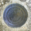
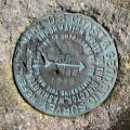
SKYLAND B
NGS
Gravity Station Disk
Virginia
Madison County
Big Meadows Quad
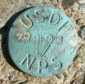
789+00 TEI
National Park Service
Unspecified Disk
Virginia
Madison County
Big Meadows Quad
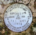
118 MLS
NGS
Bench Mark Disk
Virginia
Madison County
Big Meadows Quad
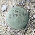
WL27+377
Unknown
Unspecified Disk
Virginia
Madison County
Old Rag Mountain Quad
THORO ERDL AZ MK 2
NGS
Azimuth Mark Disk
Virginia
Madison County
Old Rag Mountain Quad
THORO ERDL AZ MK 1
NGS
Azimuth Mark Disk
Virginia
Madison County
Old Rag Mountain Quad
THORO ERDL RM 2
NGS
Reference Mark Disk
Virginia
Madison County
Old Rag Mountain Quad
THORO ERDL RM 1
NGS
Reference Mark Disk
Virginia
Madison County
Old Rag Mountain Quad
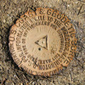
THORO ERDL
NGS
Triangulation Station Disk
Virginia
Madison County
Old Rag Mountain Quad