Skip to content
Zhanna's SurveyStation
Menu
About
Recoveries
NGS Reports
USGS Reports
Search Recoveries
Map of Recoveries
Browse By Year
Local Databases
USGS Datasheets
Airway Beacons
About Airway Beacons
Eastern U.S.
Western U.S.
Map of Airway Beacons
Historical Airway Maps
Resources
Contact
Zhanna's SurveyStation
Menu
About
Recoveries
NGS Reports
USGS Reports
Search Recoveries
Map of Recoveries
Browse By Year
Local Databases
USGS Datasheets
Airway Beacons
About Airway Beacons
Eastern U.S.
Western U.S.
Map of Airway Beacons
Historical Airway Maps
Resources
Contact
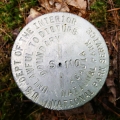
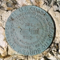
Location:
Hancock County
TOW
NGS
Landmark/Intersection Station
Maine
Hancock County
Seal Harbor Quad
S 110
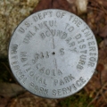
National Park Service
Boundary Monument
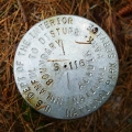
Maine
Hancock County
Southwest Harbor Quad
S 116
National Park Service
Boundary Monument
Maine
Hancock County
Seal Harbor Quad
S 114
National Park Service
Boundary Monument
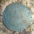
Maine
Hancock County
Seal Harbor Quad
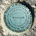
BILLINGS RM 2
NGS
Reference Mark Disk
Maine
Hancock County
Sargentville Quad
BILLINGS RM 1
NGS
Reference Mark Disk
Maine
Hancock County
Sargentville Quad
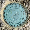
BILLINGS RESET
NGS
Triangulation Station Disk
Maine
Hancock County
Sargentville Quad
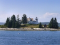
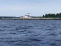
PUMPKIN ISLAND LIGHTHOUSE
Unknown
Landmark/Intersection Station
Maine
Hancock County
Sargentville Quad
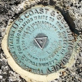
LITTLE DEER ISLE RM 2
NGS
Reference Mark Disk
Maine
Hancock County
Sargentville Quad
LITTLE DEER ISLE RM 1
NGS
Reference Mark Disk
Maine
Hancock County
Sargentville Quad
Older posts
Newer posts
←
Previous
Page
1
…
Page
5
Page
6
Page
7
…
Page
20
Next
→