TOW (PE1779)
TOW
Spatial/elevation data
| Coordinates | N 44.255554° W 68.213225° |
| Elevation | 3 ft. |
| Location | Maine
Hancock County Seal Harbor Quad |
Mark description
| Type | Landmark/Intersection Station |
| Setting | Tower |
| Monumented | 1944 by NGS |
| Description (NGS) | NGS Datasheet |
NGS recovery information
Descriptive text
Tower recovered in good condition. This former U.S. Life-Saving Station is now a private residence.Narrative and photographs
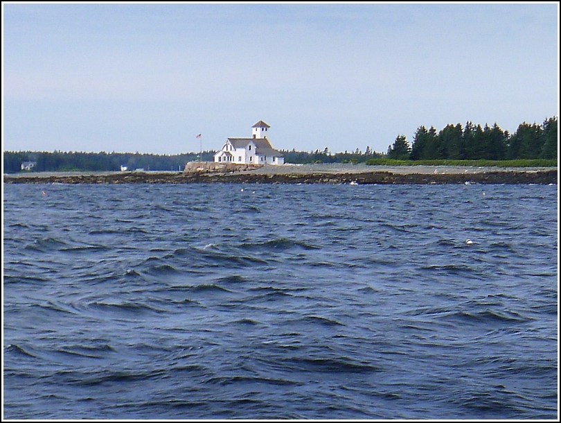
On our way to Baker Island, Rich and I monitored the GPS from time to time as we passed the typical landmarks (Porcupines, Egg Rock, Thrumcap, East Bunker Ledge [site of BUNKER LEDGE MONUMENT]) waiting for the approach of Islesford and the landmark station, TOW, that is supposed to be on its southeastern tip. By the time we were nearing the Cranberries, the wind had picked up as well as the waves, and the boat was rocking side to side. I was able to get a few photos of the tower on the old station from the boat regardless of the motion; we weren’t sure how good a view we might have from Baker Island, so we wanted to get a half decent shot while we could. Of course, we discovered as soon as we got to Baker Island that we had a perfect view of TOW from the shore.
The exterior of the building has been fixed up and the interior remodeled, but there is no indication that the structure or the tower have been moved or significantly altered in any way. It is now privately owned and maintained as a rental property.
On the return trip to Bar Harbor, someone asked about the building and the ranger mentioned that it had been U.S. Life-Saving Station #4. The U.S. Life-Saving Service was a predecessor to the Coast Guard, founded formally in 1878 to assist mariners in distress. The surfmen were pretty badass guys all around! The ranger quoted their unofficial motto as “You have to go out; you don’t have to come back.”
