Skip to content
Zhanna's SurveyStation
Menu
About
Recoveries
NGS Reports
USGS Reports
Search Recoveries
Map of Recoveries
Browse By Year
Local Databases
USGS Datasheets
Airway Beacons
About Airway Beacons
Eastern U.S.
Western U.S.
Map of Airway Beacons
Historical Airway Maps
Resources
Contact
Zhanna's SurveyStation
Menu
About
Recoveries
NGS Reports
USGS Reports
Search Recoveries
Map of Recoveries
Browse By Year
Local Databases
USGS Datasheets
Airway Beacons
About Airway Beacons
Eastern U.S.
Western U.S.
Map of Airway Beacons
Historical Airway Maps
Resources
Contact
Location:
Hancock County
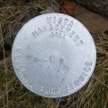
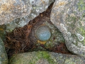
20 R ALT
National Park Service
Vista Management Area Disk
Maine
Hancock County
Southwest Harbor Quad
POR 1944
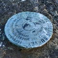
NGS
Topographic Station Disk
Maine
Hancock County
Bar Harbor Quad
12487-31
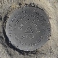
MaineDOT
Survey Control Mark
Maine
Hancock County
Bar Harbor Quad
BROWN MOUNTAIN RM 2
NGS
Reference Mark Disk
Maine
Hancock County
Southwest Harbor Quad
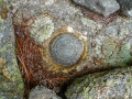
BROWN MOUNTAIN RM 1
NGS
Reference Mark Disk
Maine
Hancock County
Southwest Harbor Quad
BROWN MOUNTAIN
NGS
Copper Bolt
Maine
Hancock County
Southwest Harbor Quad
Q 145
NGS
Bench Mark Disk
Maine
Hancock County
Southwest Harbor Quad
EGG ROCK LIGHTHOUSE 1902
NGS
Landmark/Intersection Station
Maine
Hancock County
Seal Harbor Quad
WINTER HARBOR LH
NGS
Landmark/Intersection Station
Maine
Hancock County
Schoodic Head Quad
16718-10
MaineDOT
Drill Hole
Maine
Hancock County
Seal Harbor Quad
Older posts
Newer posts
←
Previous
Page
1
…
Page
7
Page
8
Page
9
…
Page
20
Next
→