K 8 USGS RESET 1977 (PE1664)
K 8 USGS RESET 1977
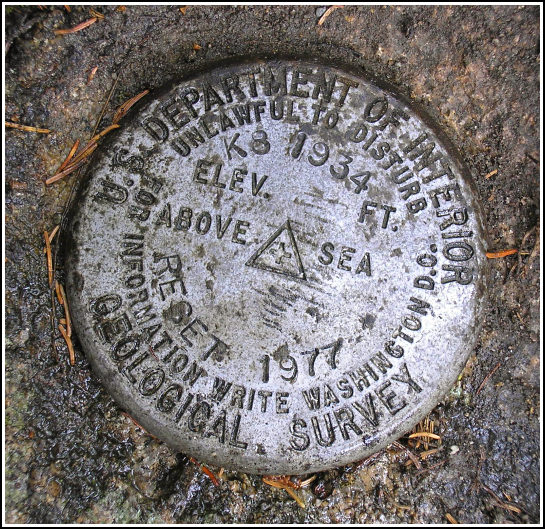
Spatial/elevation data
| Coordinates | N 44.36425° W 68.30863° |
| Elevation | 46.1 ft. |
| Location | Maine
Hancock County Southwest Harbor Quad |
Mark description
| Type | Bench Mark Disk |
| Setting | Rock Outcrop |
| Monumented | 1977 by USGS |
| Description (NGS) | NGS Datasheet |
NGS recovery information
Descriptive text
Recovered in good condition. Handheld GPS coordinates for the mark are 44 21 51.3(N) 068 18 31.3(W).Narrative and photographs
The day was (and we were) really wet by the time we reached the junction of Routes 233 and 198. Fortunately, Rich had already found this mark several years ago, so we could simply park and run directly to it. He held back the branches of a nearby tree so I could get a decent view, and I took some quick photographs while trying to keep the camera dry. Like the others along this route, this disk is in good condition. We did not see the utility pole mentioned in the description.


(Recovered on September 12, 2002)
N 44° 21.859’ W 068° 18.519’
While vacationing on M.D.I. I decided to search for a few local benchmarks. I drove out along Route 233 from Bar Harbor to the intersection of Route 198 and with some difficulty found the mark using the distances & bearings in the historical description. At the station my Garmin GPSmap76 receiver indicated approximately 394 feet from the posted coordinates. The disc was buried under three inches of dirt and moss and not at all visible, but it is in very good condition. ~Rich in NEPA~


