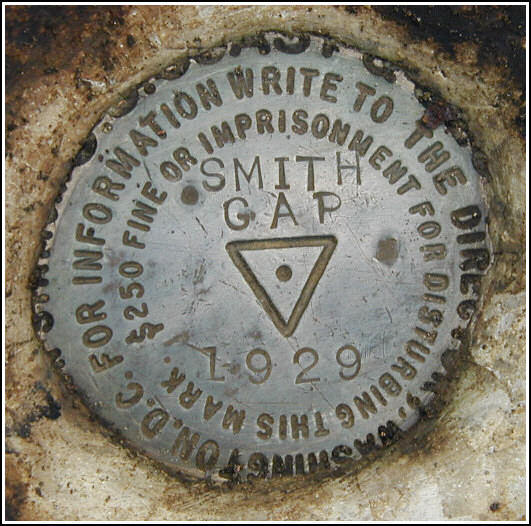
SMITHS GAP RESET
Spatial/elevation data
| Coordinates | N 40.822733° W 75.422416° |
| Elevation | 1611 ft. |
| Location | Pennsylvania
Northampton County Kunkletown Quad |
Mark description
| Type | Triangulation Station Disk |
| Setting | Bedrock |
| Monumented | 1929 by NGS |
| Description (NGS) | NGS Datasheet |
NGS recovery information
Descriptive text
The station mark and reference marks 1 and 3 were recovered in good condition. The 1942 description is adequate, with the following additions. Kunkletown-Port Phillip Rd. is now called Smith Gap Road. There is a small parking area at the point where the Appalachian Trail crosses this road. The blazed tree was not found. The station mark is now approximately one foot below the surface of the ground, is covered by loose soil and several flat stones, and is surrounded by a circle of rocks approximately 6 feet in diameter. Reference mark 1 is covered by several flat rocks.Narrative and photographs
Though it was our main goal for the day, we saved the recovery of SMITHS GAP RESET for the second half of our day, following the search for Sasha’s Cache in the gamelands to the south. After finding the cache and climbing back up the steep hill to Smith Gap, we headed in on the Appalachian Trail toward the triangulation station. It was a short walk—0.5 miles along the A-T—to the point where our GPSrs were directing us off the trail to the south. I think I could distinguish a dim trail to the station at this point, but it’s far from certain.
When we arrived near the coordinates for the station, its location was obvious. Not only was there a depression in the ground surrounded by rocks roughly forming a circle, but there were also remnants of white plastic material used to mark the station for aerial surveys. We dug down and removed a few stones, enough to verify that this was indeed the mark, and then we went in search of the reference marks.
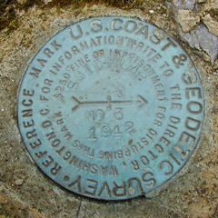
Reference marks 1 and 3 were located without much difficulty using only the bearings given on the datasheet and estimating distances as we walked. RM1 was found beneath a pile of flat stones, possibly serving as protection. RM3 is exposed and is of a bright blue-green color, so it was easy to spot from a distance.
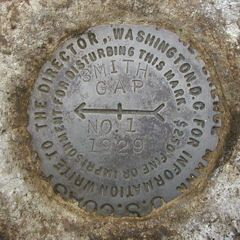
The soil, roots and rocks were cleared from the station and the station disk was cleaned, and photographs were taken. As noted in the 1942 recovery, the marks are stamped SMITH GAP instead of SMITHS GAP, which is given as the designation. All are in good condition. Before leaving the area (rather quickly, due to the sudden drop in temperature and feeling of impending precipitation in the air) we re-buried the station mark, returning it to the condition in which we’d found it. Similarly RM1 was covered again with stones.


Station recovered in good condition.
This first order triangulation station is situated atop the ridge of Blue Mountain at Smith Gap (as the designation implies), almost directly on the border of Northampton and Monroe counties, approximately 275 feet south of the Appalachian Trail (the triangle-blazed tree and the dim trail were not found), and 0.5 miles west-south west of a small parking area at the A-T crossing on Smith Gap Road. The 1942 “to reach” directions are still fairly usable. A handheld GPS receiver was helpful in pinpointing the location of the station. It appears the brush in the area has grown in considerably from when the station was re-monumented in 1929.
The station and its two reference marks were found as described. The station mark is set in the top surface of a concrete monument within a shallow depression in the ground and surrounded by a rough circle of stones about 6 feet in diameter. It was covered over with some flat rocks and a few inches of loose, loamy soil containing a mass of fine roots. The mark itself is about 1 foot below ground level. Also found were sections of tattered and aged white plastic sheeting which was obviously placed over the station in the shape of a large cross of the kind used as a target for an aerial survey. RM 1 was covered by some flat stones to hide it. RM 3 is in the open and well exposed.
At the station a Garmin GPSmap76 receiver with active remote antenna was used to record WAAS-corrected coordinates which were identical (within 0.001 minute) to the adjusted coordinates listed on the NGS datasheet. All marks are in good condition and the stamped designations are legible. The station mark was re-buried as originally found, and RM 1 was covered over again with flat stones.
~Rich in NEPA~


| Designation | Status | Condition | Image |
|---|---|---|---|
| SMITHS GAP RESET RM 1 | Recovered | Good |
|
| SMITHS GAP RESET RM 3 | Recovered | Good |
|