JIM THORPE MAUCH CHUNK LOT (KV3846)
JIM THORPE MAUCH CHUNK LOT
Spatial/elevation data
| Coordinates | N 40.873683° W 75.69945° |
| Elevation | Unknown |
| Location | Pennsylvania
Carbon County Lehighton Quad |
Mark description
| Type | Landmark/Intersection Station |
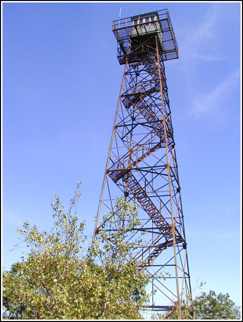
| Setting | Fire Lookout Tower |
| Monumented | 1969 by NGS |
| Description (NGS) | NGS Datasheet |
Narrative and photographs
I located this tower while on a biking adventure with Rich in NEPA. Our main goal on Bear Mountain was to locate the THORPE triangulation station, but we were also aware that this fire tower had a PID and could be logged. The tower appears to be in good condition. Not too many of these are still standing, so it’s always a treat when we find one. It’s just a shame the tower wasn’t open to climb. I’m sure the view from the top is breathtaking.

This third order horizontal station is located on the summit of Bear Mountain. It can be accessed by following Route 903 north from Route 209 at the town of Jim Thorpe to a right turn onto Maury Road, and then to a right turn onto Fire Tower Road. There is a Mauch Chunk Forest Fire Tower sign at the turn-off. A locked gate bars vehicular access to the dirt road so it’s necessary to hike or bike roughly 1¾ miles up to the lookout tower. It was not possible to occupy the center of the base of the tower and therefore GPS coordinates were not obtained. ~Rich in NEPA~
