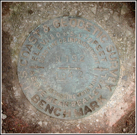
N 192 (KV2820)
N 192
Spatial/elevation data
| Coordinates | N 40.843916° W 75.8054° |
| Elevation | 1064.41 ft. |
| Location | Pennsylvania
Carbon County Nesquehoning Quad |
Mark description
| Type | Bench Mark Disk |
| Setting | Round Concrete Monument |
| Monumented | 1942 by NGS |
| Description (NGS) | NGS Datasheet |
Narrative and photographs
Even though I wasn’t really supposed to, I had the day off from work—and what better way to spend it than to go for a ride (and hunt benchmarks) in Jim Thorpe. Rich and I incorporated this hunt into a ride on Switchback Trail, which we eventually rode all the way up to the Mt. Pisgah Summit Overlook. We were especially excited about this mark because, according to the information found on the geocaching website, this mark had last been reported Not Found by the U. S. Power Squadron (we didn’t discover till later that two subsequent Found reports have been submitted by PennDOT). Nothing was apparent at first glance, but Rich kicked some grass aside at just the right spot, and there was the mark! We made several measurements to update the description, and brushed clean the disk and monument. The disk is in good condition and the stamping can be read easily.


N 40° 50.639’ W075° 48.324’
Found as described in the 1942 history!
This second order vertical control station is set in the top of a round concrete monument flush with the ground near the entrance to Mauch Chunk Lake Park. The historical description leads reliably to the station, but the white witness post, the right-of-way fence, and the 4-foot oak tree no longer exist. The town of Mauch Chunk is now called Jim Thorpe, and the county road is named Lentz Trail. The mark was partially obscured by dirt and grass. In addition, it is roughly 18 feet north of a 6x6x3’ post for a sign “Switchback Trail,” roughly 4 feet north-northeast of a 3’x4’x1’ flat boulder, and roughly 60 feet northeast of a sign “Mauch Chunk Lake Park” that is located between separate lanes of the park driveway. The surface of the monument was cleared and the disk is now well exposed. At the station a Garmin GPSmap76 receiver with remote active antenna was used to record autonomous (non-corrected) coordinates which were 48.7 feet from the scaled coordinates listed on the NGS datasheet. The disk is in very good condition and the stamped designation is legible. ~Rich in NEPA~


