THORPE (KV3845)
THORPE
Spatial/elevation data
| Coordinates | N 40.8735° W 75.6996° |
| Elevation | 1682 ft. |
| Location | Pennsylvania
Carbon County Lehighton Quad |
Mark description
| Type | Traverse Station Disk |
| Setting | Boulder |
| Monumented | 1969 by NGS |
| Description (NGS) | NGS Datasheet |
NGS recovery information
Descriptive text
Shank still in place. [submitted via Deb Brown]Narrative and photographs
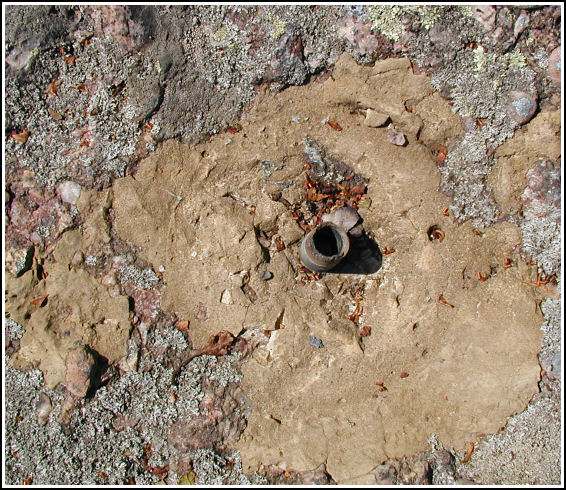
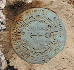
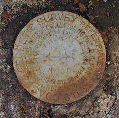
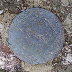
On a whim, before mountain biking at nearby State Gamelands as we’d planned, Rich and I decided to attempt to locate the THORPE station and reference marks. It was a simple matter to follow Route 903 to Maury Road and then to park at the bottom of Fire Tower Road. This road is blocked to cars by a locked gate, so it was fortunate that we had our bikes with us for the 1-3/4 mile climb to the tower. Once at the coordinates, though, we were disappointed to discover that the station disk is missing, having been pried off. Nothing but the stem, embedded in the boulder, remains. Both reference marks were located easily, and they are both in fair condition. Before leaving Bear Mountain, we photographed the fire tower as well as a Carbon County GPS survey station mark that Rich located on another of the enormous boulders, not far from station THORPE. The azimuth mark, located along Route 903, was found later in the afternoon. The disk was easy to spot; finding a safe place to park was more difficult than locating the mark. This disk is in excellent condition. Interestingly, the fire tower can be viewed from the azimuth mark.
Based on our report to NGS, it was determined that the mark would not be officially destroyed, but would be marked as recovered in poor condition.

This second order horizontal traverse station is located at the summit of Bear Mountain. The 1969 historical description leads reliably and easily to the station and all reference marks. The paved road off Route 903 is called Maury Road, and the sign for the Mauch Chunk Forest Fire Tower still exists at the base of Fire Tower Road. There is a locked gate at the start of the dirt road so it is necessary to hike or bike roughly 1¾ miles up to the station. The station mark was found mutilated—the disk portion with the stamped designation has been pried off, and only the stem remains embedded in the drill hole. At the station a Garmin GPSmap76 receiver with active remote antenna indicated 11 feet from the adjusted coordinates on the NGS datasheet. The disk for RM1 is in good condition, and the disk for RM2 is in fair condition. Both are well exposed and the stamped designations are still legible upon close examination. The azimuth mark is well exposed, in excellent condition, and the stamped designation is highly legible. ~Rich in NEPA~
[Note: The criterion for logging this recovery as “Found” is positive identification, and since the reference marks are all intact they provide sufficient evidence of the station’s exact location and identity. Also, the station is not being logged as “Destroyed” because it is still viable in spite of the missing marker. Subsequently its condition is described as “Poor” pending final determination by NGS.]


| Designation | Status | Condition | Image |
|---|---|---|---|
| THORPE AZ MK | Recovered | Good |
|
| THORPE RM 1 | Recovered | Good |
|
| THORPE RM 2 | Recovered | Fair |
|