FOUR CORNERS=GLO STA 1 (GO0497)
FOUR CORNERS=GLO STA 1
Recovered in Destroyed Condition on September 14, 2008

Spatial/elevation data
| Coordinates | N 36.998971° W 109.045169° |
| Elevation | 4862 ft. |
| Location | Arizona
Apache County Teec Nos Pos Quad |
Mark description
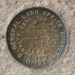
| Type | Survey Disk |
| Setting | Square Concrete Monument |
| Monumented | 1934 by U. S. General Land Office |
| Description (NGS) | NGS Datasheet |
Narrative and photographs
This was the original Four Corners monument. In 1992 it was destroyed and replaced with the current monument (as of our visit in 2008), CO UT AZ NM (AD9256). We took a quick look for the reference marks and found one of them, RM 2, on the open land west of the four corners station.
| Designation | Status | Condition | Image |
|---|---|---|---|
| FOUR CORNERS=GLO STA 1 RM 2 | Recovered | Good |
|