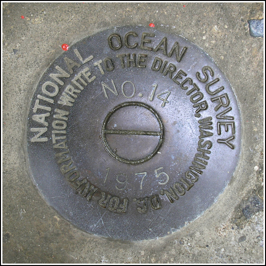
841 3320 TIDAL 14
Recovered in Good Condition on June 26, 2006
Spatial/elevation data
| Coordinates | N 44.390133° W 68.2048° |
| Elevation | 15.08 m. |
| Location | Maine
Hancock County Bar Harbor Quad |
Mark description
| Type | Tidal Bench Mark Disk |
| Setting | Concrete Foundation |
| Monumented | 1975 by National Ocean Service |
| Description (National Ocean Service) | The bench mark is a disk set in the concrete foundation of the rock wall at the entrance to the Testes Restaurant parking lot, 40.84 m (134.0 ft) NNE of the restaurant’s main entrance, 7.92 m (26.0 ft) west of the centerline of Main Street, and 0.76 m (2.5 ft) south of the fire hydrant encircled by the granite wall. |
Narrative and photographs
Though datasheets are not known for being laugh-inducers, the description for this mark had us in stitches all week—and not just after we’d been drinking 3 Blind Moose. (Check out the unfortunate misspelling of “Testa’s Restaurant”.) I just knew we’d have to search for it before our vacation time ran out. The misty morning of Monday, June 26, our last full day in Maine, offered us just the perfect moment. After a lovely breakfast at Jeannie’s (try the Eggs Benedict and crabmeat omelet!!!), we wandered around town in the drizzle and occasional sunshine. The bright red fire hydrant is like a beacon drawing one’s attention to the mark. It cannot be overlooked!

