TT 2 H
TT 2 H
Spatial/elevation data
| Coordinates | N 41.27635° W 75.626733° |
| Elevation | Unknown |
| Location | Pennsylvania
Lackawanna County Scranton Quad |
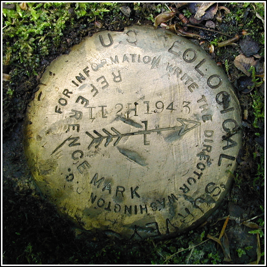
Mark description
| Type | Transit Traverse Station Disk | ||||||
| Setting | Boulder | ||||||
| Monumented | 1943 by USGS | ||||||
| Description (USGS) | Moosic, 8.3 mi along hwy., rds., and trail SE. to chlorination plant of Scranton Spring Brook Water Supply Co., thence 1 mi along dim woods trail up N. side of Big Panther Creek and 1 mi along W. side of branch of Spring Brook S.; about 0.2 mi from point where foot trail enters timber at S. edge of abandoned field; 3 ft S. and 21 ft W. of 8-in. oak tree with triangular blaze; in center of foot trail; in top near center of large boulder; standard tablet stamped “TT 2 H 1943”
|
USGS recovery information
View reportNarrative and photographs
TT 2 H was the second of the two USGS marks we had learned about when viewing maps of this area prior to searching for the Painter Creek Cache a few weeks ago. We knew we wouldn’t have time to search for both marks that day, so we focused on TT 1 H, which is the closer of the two to the geocache, and planned to come back to search for TT 2 H.
Today we returned to the area, ready to search for the second mark. We estimated about a 6-mile one-way trip to the mark, so we brought our bikes today to make travel a bit easier and quicker. We parked at the Pinchot Trail parking lot near the intersection of Bear Lake Road and Pittston Road, then rode up Pittston Road to the point where the Painter Creek Trail branches off to the north-northeast. After a half mile the trail turns to the east (the Watres Trail joins to the north) and we continued on the Painter Creek Trail. After another half mile, perhaps a bit more, we joined the Hayes Run Trail, and old trail (quite overgrown) which we planned to follow to the mark.
At the time of our visit this entire area was overgrown and soggy, muddy, and rather miserable! We had to ditch our bikes at one point, stashing them against a tree (for which we marked a GPS waypoint!), and bushwhack around the vegetation to make our way to the mark. The mark was, as described, set on a rock flush with the ground right in the middle of the trail. Strangely enough, just like TT 1 H, a reference mark disk was used for this station, which is actually a transit traverse station. And also like TT 1 H (I assume because the same crew was responsible for setting both marks), the “T”s are stamped from upside-down “1”s.

