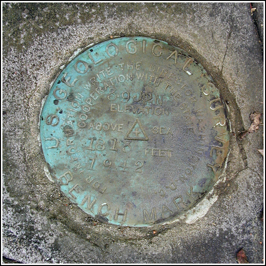
39 JPN
39 JPN
Spatial/elevation data
| Coordinates | N 41.260283° W 75.596033° |
| Elevation | 1812.856 ft. |
| Location | Pennsylvania
Lackawanna County Scranton Quad |
Mark description
| Type | Bench Mark Disk |
| Setting | Boulder |
| Monumented | 1942 by USGS |
| Description (USGS) | Moosic, 8.5 mi SE. of, along hwy., thence 4.2 mi SE. along dirt rd. and trail; 75 ft SE. and 60 ft NE. of crossing of trail and small brook; in embedded boulder projecting about 0.5 ft above ground; standard tablet stamped “39 JPN 1942 1813”. Elev. 1812.856 ft. Reference mark; 27 ft S. of tablet; on small boulder; chiseled square. Elev. 1814.46 ft. |
USGS recovery information
View reportNarrative and photographs
On miserable days when I just can’t spend time outdoors, I love to “explore” by going through my maps and studying areas that intrigue me. Rich and I had both been interested in this so-called “Boar Hole” and the network of trails and old roads and railbeds surrounding it, and we chose this chilly May Sunday to explore the area in person. A bonus, for me, was the numerous benchmarks in the area, mostly along the old railroad bed from north of the Boar Hole (Old Pittston Road) down through Clifton and all the way south to Brady’s Lake. Of course we wouldn’t be able to tackle the whole area in one excursion, so we decided to focus on the northern part (including the Boar Hole) this time.
We’ve hunted the gamelands near Clifton so we were familiar with the parking area and the steep hill down to the railbed, but from there it was all new to us. We didn’t even know how rideable the trails would be, but our scouting mission turned into a full-morning ride once we realized that the trails were in perfect condition and the scenery was green and gorgeous.
The first mark we attempted to find was a chiseled square on a rock at the intersection of the railbed and an old road. We were unsuccessful, as the and the rock was likely buried beneath several decades’ worth of dirt and forest debris. We did find a lovely “spring surrounded by rocks,” to quote from the description of another elusive benchmark in the Scranton area.
From here we rode on to the next mark on our list, 39 JPN. This one took us off the railbed and up a hill into open woods and fields. Following the directions in the description led us directly to the mark, which was easy to spot because of its bright turquoise color. The disk is in good condition. We were unable to locate the reference mark.
We backtracked to the railbed and continued on to the Boar Hole, which as you may have suspected is actually an enormous bore hole serving as a culvert through the steep narrow ridge that carries the railbed through the turn and over the creek. Massive rock ledges and cuts abound along this route, and we followed the railbed all the way to its sharp and dramatic end at a steep dropoff where, apparently, a trestle once carried the tracks over a wide valley. Nothing remains of this trestle but some crumbling pieces of an abutment and supports.


