TT 1 H
TT 1 H
Spatial/elevation data
| Coordinates | N 41.2943° W 75.6223° |
| Elevation | Unknown |
| Location | Pennsylvania
Lackawanna County Scranton Quad |
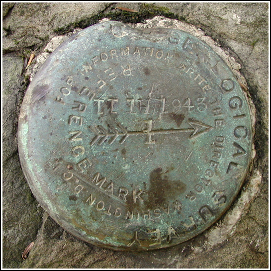
Mark description
| Type | Transit Traverse Station Disk |
| Setting | Boulder |
| Monumented | 1943 by USGS |
| Description (USGS) | Moosic, 8.3 mi SE. of, along hwy., rds., and trail to chlorination plant of Scranton Spring Brook Water Supply Co., thence along W. side of Spring Brook Creek; 8 ft S. and 11 ft E. of SE. corner of plant (single story white concrete block building); in top near N. end of large boulder; standard tablet stamped “TT 1 H 1943”. |
USGS recovery information
View reportNarrative and photographs
Several weeks ago, while searching USGS datasheets and topo maps, I noticed two interesting marks in the Painter Creek area. Skipsp’s new Painter Creek geocache gave us yet another reason to visit and explore this area. We chose a beautiful Wednesday morning for our adventure. Our goal was simply to find the cache, explore the area and possibly scout out the mark nearest to the parking area (we knew we’d have to leave the second mark for another day).
The USGS datasheet omits coordinates for this mark, but I did take a guess from the map. We discovered some beautiful, magical spots while chasing down these coordinates, but never got close enough to search for the mark or even the chlorination plant. Eventually I sat down with the description and realized I’d made a mistake, and that the building shown on the map was most likely not the old chlorination plant. We’d been trying to get to the east side of the creek, but the west side of the creek was where we wanted to be—and where we’d been walking all along!
On our walk back to the car, we came across a platform, some old concrete and cinder blocks right at an intersection of woods roads. There was a pipe and manhole nearby. Could this have been the plant? It seemed likely, but several yards southeast of the southeast corner of the building platform—where we should have found the boulder and mark—put us right in the middle of the woods road that branches northwest off the main (north-south) road. If the boulder had been here, we concluded, it wasn’t any longer. But it wasn’t two minutes later that Rich, poking around among the rubble and boulders between the main woods road and the creek, spotted the disk! From the appearance of the boulder and the other debris in the area, we think it was plowed from its original location and pushed off to the east side of the north-south woods road. The mark is now 22 feet at 104° magnetic from the center of the intersection of woods roads. The disk itself is in good condition, but is useless if it truly has been moved. For some reason, a reference mark disk was used rather than a typical bench mark disk. The “T”s are made from upside-down “1”s.

