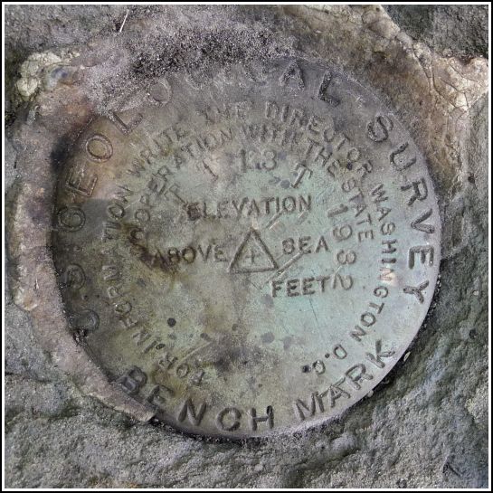
TT 13 T
Spatial/elevation data
| Coordinates | N 41.54645° W 75.39091° |
| Elevation | 1428.25 ft. |
| Location | Pennsylvania
Wayne County Waymart Quad |
Mark description
| Type | Transit Traverse Station Disk | ||||||
| Setting | Rock Outcrop | ||||||
| Monumented | 1932 by USGS | ||||||
| Description (USGS) | South Canaan, 3.6 mi NE. of; 2.1 mi N. of East School; on State Highway 159; 127 ft NE. of crossroad (rd. W. is third-class); in large rock outcrop; standard tablet stamped “TT STA NO 13 T 1932”
|
Narrative and photographs
TT 13 T was next on our list after our success at nearby Keen Lake. As we drove by the coordinates I had estimated from the topo map, all we could see was swamp—in fact, deep standing water, and no sign of a large rock outcrop. The description was vague, too. The situation required in-person investigation.
Rich parked at the intersection of T 435 (Layton Road) and Tuthill Road. As soon as I walked a few yards northeast along Tuthill Road, I could see a large rock outcrop east of the road, just inside the tree line. Unwilling to wade through the weeds, which most certainly contained poison ivy (of course), I scouted the rock outcrop with the help of binoculars. I still couldn’t see a disk, but with no other outcrops anywhere nearby, I was sure this was the correct one. I took a chance and picked my way delicately through the weedy border (which did contain a small amount of P.I., but a much larger quantity of dewberry). I was soon standing right over the mark. It was well camouflaged, but easily spotted from just a few feet away.
The disk is in excellent condition and is solid in its setting in the outcrop. It is easily accessible so is probably a good choice for surveyors to use. We didn’t, however, see any indications of recent use like nearby flagging tape or paint.


