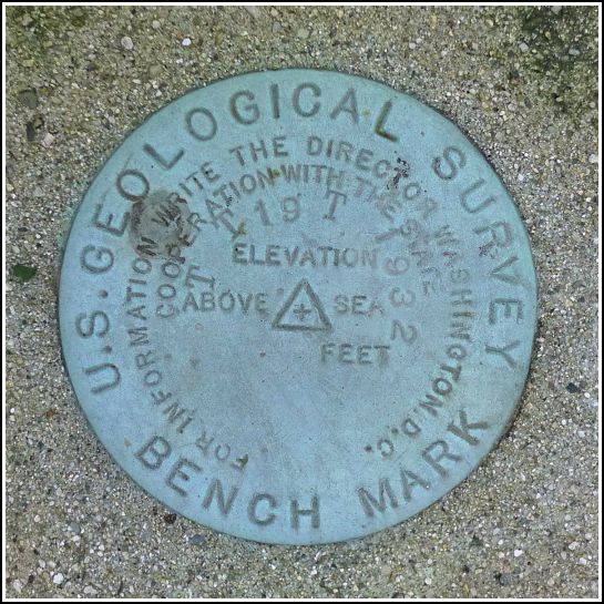
TT 19 T
TT 19 T
Spatial/elevation data
| Coordinates | N 41.54808° W 75.43334° |
| Elevation | 1559.794 ft. |
| Location | Pennsylvania
Wayne County Waymart Quad |
Mark description
| Type | Transit Traverse Station Disk | ||||||
| Setting | Concrete Post | ||||||
| Monumented | 1932 by USGS | ||||||
| Description (USGS) | South Canaan, 2.5 mi N. and 1.2 mi W. of; 2.9 mi SW. of Waymart; 1.7 mi N. of Spangenberg School; on old station rd.; 800 ft N. of Arnold farmhouse; on Canaan and South Canaan Township line; 200 ft E. of E. & H. RR.; 44 ft W. of rd.; in concrete post; standard tablet stamped “TT STA NO 19 T 1932”
|
Narrative and photographs
Our third mark for today took us on a winding country road adventure. The panoramic views of the windmills from Robinson Road were a real treat! Much of the description is long out of date, but we trusted that the coordinates I’d pulled from the topo map would get us within twenty feet of the mark, as they typically do. We drew close to the coordinates and found ourselves nearing the base of a gravel driveway, with a wooded patch to the north. We drove by slowly, not expecting to see much from the road. But in an instant, we both spotted a yellow-painted post several yards into the woods!
We parked and walked up the driveway to find a bare-chested man watching us warily. I think he had an eyebrow raised—maybe he thought we were selling something. Fortunately, he was very friendly, knew exactly where the mark was, and was excited to show us. We told him we had already spotted it from the road and just wanted permission to enter the woods and take a few photos. The man said, “Sure, absolutely, go ahead!” and then went on to tell us that we weren’t the first. A few years ago, some other people had stopped by to check on the mark. They spent a few minutes in the woods just verifying the mark’s condition, he assumed, and then they left. Rich and I are still wondering who they might have been! PennDOT, or maybe someone from USGS? It’s highly unlikely that a geocacher would know about this mark, since it’s not in the NGS database, but I suppose it’s remotely possible.
The disk and monument are in near-perfect condition. They have a good caretaker who, he said, clears the area of excess growth because he recognizes the importance of the mark. We showed him the description, but he was unfamiliar with some of the older landmarks mentioned, like the Arnold farmhouse and the Spangenberg School.


