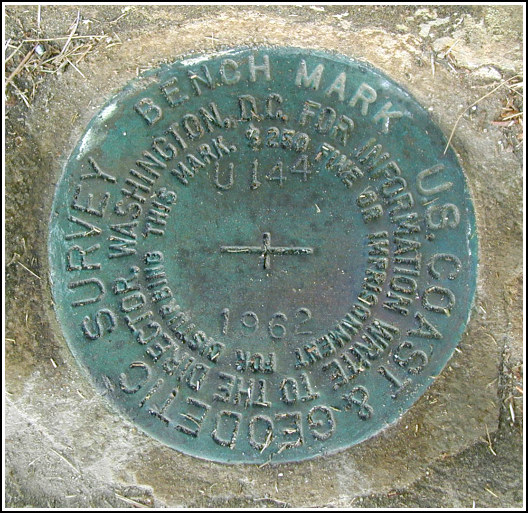
U 144 (PE0280)
U 144
Spatial/elevation data
| Coordinates | N 44.380316° W 68.223083° |
| Elevation | 202.64 ft. |
| Location | Maine
Hancock County Bar Harbor Quad |
Mark description
| Type | Bench Mark Disk |
| Setting | Rock Outcrop |
| Monumented | 1962 by NGS |
| Description (NGS) | NGS Datasheet |
NGS recovery information
Descriptive text
Recovered in good condition. There is no longer a fence at this location. Handheld GPS coordinates for the station are 44 22 49.1(N) 068 13 23.1(W).Narrative and photographs
After watching a less-than-spectacular but still awesome sunrise from Cadillac Mountain, for which we got up at 3:15am, Rich decided we could stop for a few benchmarks on the way back to Bar Harbor. K 23 (PE0279) was first, followed shortly thereafter by this mark. It was very easy to find, set prominently in an outcropping rock just off the road. We noted that the fence mentioned in the datasheet description was removed at some point between Rich’s initial log in 2002 and our 2005 visit.


(Recovered on September 11, 2002)
N 44° 22.822’ W 068° 13.381’
While vacationing on M.D.I. I decided to search for a few local benchmarks. I drove out along Route 233 from Bar Harbor and easily found the mark using the historical description. At the station my Garmin GPSmap76 receiver indicated approximately 90 feet from the posted coordinates. The disc is quite visible and is in excellent condition. ~Rich in NEPA~


